
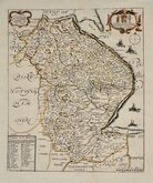
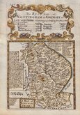
Nottinghamshire Maps
Lincolnshire Maps
( Page 1 of 3 )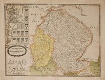
Christopher Saxton 1579 [1693]
Richard Blome 1673
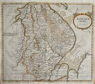
Robert Morden 1695
Emanuel Bowen 1720
Thomas Read 1744 [1769]
Thomas Kitchin 1763
Joseph Ellis 1765 [1773]
Nathaniel Coltman 1806 [1809]


42x37 cm
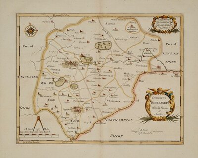
FIRST MAP OF THE COUNTY TO SHOW LONGITUDE FROM LONDON.
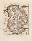
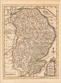
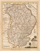
LINCOLN : SHIRE
By Robert Morden
Copper engraving produced by Robert Morden (fl.1669-1703) for publication in Edmund Gibson's translation of William Camden's Britannia first published by Abel Swalle and Awnsham & John Churchill in 1695. Engravers Sutton Nichols and John Sturt have signed some of the maps but probably other engravers were also employed.
This is the first series of maps to mark longitude in minutes of time (top border) as well as in degrees (bottom border). For most counties longitude is based on the meridian of St. Paul's, London. They were also the first folio sized series of county maps to show roads, Morden using the survey and strip road maps of John Ogilby published in his road book, also entitled Britannia, in 1675. Morden produced a set of playing card maps in 1676, shortly after Ogilby’s production, which were actually the first set of county maps to include roads. Morden did not use Ogilby's measure for the mile of 1760 yards which later became the accepted standard, but used a somewhat arbitrary approximation of local variations for the mile to include three scales, 'Great', 'Middle' and 'Small' miles on his maps.
The work was republished in 1722, 1730, 1753 and, finally in 1772. There were a number of minor alterations to most plates during the early editions and they were substantially updated for the 1722 edition mostly with changes to place name spellings. Due to wear caused by the printing process the plates were reworked for the 1753 edition.
A couple of thin areas of paper in the blank areas of Yorkshire and Norfolk with small holes but the hand made rag paper for this edition was made thin and lighweight an the edition can be identified by this quality. A very good example from the first edition in neat later hand colour.
Ref. Carroll Printed Maps of Lincolnshire 20(i).
Quick Links


Cambridgeshire Maps
Rutland Maps
×