
Northamptonshire Maps
Rutland Maps
( Page 1 of 2 )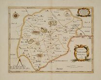
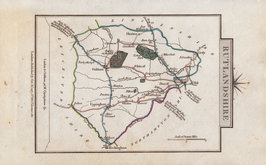
Robert Morden 1695 [1753]
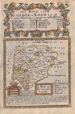
Emanuel Bowen 1720
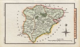
John Cary 1789 [1805]
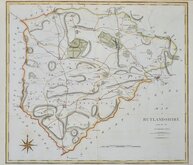
John Cary 1789 [1805]
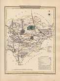
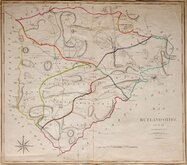
George Cole 1808
George Cole 1808 [1843]
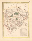
Sidney Hall 1820 [1833]
George & John Cary 1822


36x29 cm
FIRST COUNTY MAP TO SHOW LONGITUDE FROM LONDON AND LOCAL TIME
COMITATUS ROTELANDIÆ Tabula Nova & Aucta
Sold by { A. Swale A.Churchil } & Partners
Copper engraving produced by Robert Morden for publication in Edmund Gibson's translation of William Camden's Britannia first published by Abel Swalle and Awnsham & John Churchill in 1695.
This is the first series of maps to mark longitude in minutes of time from London (top border) as well as in degrees (bottom border). Minutes of time was useful during a period when time was not yet standardised across the country. For most counties longitude is based on the meridian of St. Paul's, London. For many maps in the series they were the first folio county maps to show roads, Morden making use of the survey and strip road maps of John Ogilby published in his road book, also entitled Britannia, in 1675. It was Morden's miniature maps produced on a set of playing cards in 1676 which were the first complete set of county maps to include roads. Morden did not however, adopt John Ogilby's standardisation of measure for the mile at 1760 yards preferring the somewhat arbitrary method of including three scales according to varying local measurement, of 'Great', 'Middle' and 'Small' miles. Gibson's Britannia was republished in 1722, 1730, 1753 and, finally in 1772. The maps were updated for the 1722 edition, mostly with changes to place name spellings and the plates were reworked for the 1753 edition due to wear caused by the printing process.
The Rutland plate differs in style from others in the series as Morden amended the plate for the map published in The History and Antiquities of Rutland... by James Wright...Bennet Griffin, 1684. The amendments include the addition of the border with minutes of time and degrees, an additional scale, and the publisher's imprint.
Fine example in neat later hand colour from the 1753 edition.
Quick Links


Lincolnshire Maps

Leicestershire Maps
×