
Yorkshire North Riding
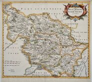
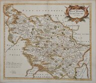
Yorkshire West Riding
( Page 1 of 3 )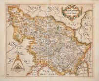
William Hole 1607 [1610]
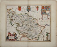
Jan Jansson 1646
Robert Morden 1695
Robert Morden 1695 [1730]
Emanuel Bowen 1720
Kitchin & Jefferys 1749
Emanuel Bowen 1750 [1753]
Emanuel Bowen 1750 [1763]


32x27 cm
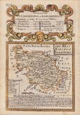
FIRST PUBLISHED MAP OF THE WEST RIDING
EBORACENSIS Comitatus pars Occidentalis vulgo WEST RIDING
Chistophorus Saxton descripsit Gulielmus Hole Sculpsit
Copper engraving by William Hole (fl.1601-1624) first published in the 6th edition of William Camden's Britannia in 1607 by George Bishop and John Norton. This was the first edition of the work to include county maps and the first publication to include separate plates for each of the English and Welsh counties.
The engraving work was shared between William Kip and William Hole and the maps were based on the Elizabethan surveys of Christopher Saxton and John Norden.
The plates were re-issued in the 7th and 8th editions of Britannia with text transated from the Latin by Philemon Holland, in 1610, twice, and in 1637. With a few exceptions, maps were unchanged in all editions but the 1607 edition were printed with Latin typeset text verso and subsequent editions were blank. A plate number was added in the second issue of 1610 which remained on the final 1637 edition. Later impressions from the 1637 edition often show signs of wear and damage to the plates.
Some toning to the map to a line in the margins at an old mountboard, otherwise a very good example from the second 1610 edition in neat later hand colour. Large watermark of a coat of arms surmounted by a crown.
Ref. Whitaker Printed Maps of Yorkshire [10]
Quick Links


Yorkshire East Riding

Whole of Yorkshire
×