
Whole of Yorkshire
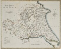
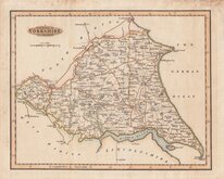
Yorkshire East Riding
( Page 1 of 2 )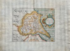
William Hole 1607
Robert Morden 1695
Emanuel Bowen 1720
Thomas Kitchin 1763 [1777]
Thomas Kitchin 1764
John Cary 1789 [1805]
Benjamin Baker 1796
George Cole 1808


25x20 cm
FIRST ISSUE. LATIN TEXT VERSO.
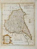
EBORACENSIS Comitatus (cvius Insolae olim Brigantes appellabantur ) pars Orientalis, vulgo EAST RIDING
Christophorus Saxton desrip: Guilielmus Hole sculpsit
Based on the Elizabethan surveys of Christopher Saxton and John Norden, these maps were the first series of county maps engraved on separate plates for each county of England and Wales. The engraving work was shared between William Kip (fl.1698-1618) and William Hole (fl.1601-1624). First published in the 6th edition of William Camden's Britannia 1607 by George Bishop and John Norton, the plates were re-issued in the 7th and 8th editions of Britannia 1610, the first publication of Britannia with text translated from the Latin into English (by Philemon Holland), with one further issue in 1637. With a few exceptions, maps were unchanged in all editions but maps from the 1607 edition were printed with Latin typeset text on the reverse and a plate number was added in the second issue of 1610 which remained on the final 1637 edition.
Good hand coloured example from the uncommon first edition published in 1607. The paper is very fine and the Latin text on the reverse shows through in the large borders and blank areas of the map but the map is a strong early impression in neat later hand colour.
Quick Links


Yorkshire North Riding

Yorkshire West Riding
×