
Yorkshire North Riding
Yorkshire West Riding
( Page 1 of 3 )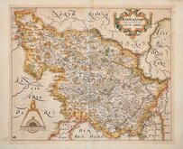
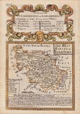
William Hole 1607 [1610]
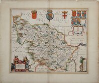
Jan Jansson 1646
Robert Morden 1695
Robert Morden 1695 [1730]
Emanuel Bowen 1720
Kitchin & Jefferys 1749
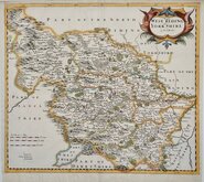
Emanuel Bowen 1750 [1753]
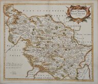
Emanuel Bowen 1750 [1763]


71x53 cm
LARGE ENGLISH ATLAS. BOWLES AND SAYER IMPRINT.
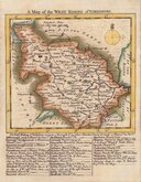
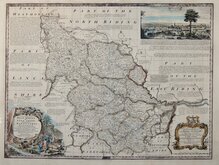
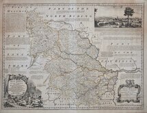
An ACCURATE MAP of the WEST RIDING of YORK SHIRE, Divided into its WAPONTAKES. Drawn from Surveys, with various additional Improvements: ILLUSTRATED with HISTORICAL EXTRACTS relative to its Natural Produce, Mines, Minerals, Manufactures, Trade and the present state of its Principal Towns.
By Eman.l Bowen Geographer to HIS MAJESTY.
Printed for Carington Bowles in S.t Pauls Church Yard. Iohn Bowles in Cornhil. & Rob.t Sayer in Fleet Street.
Dedication to Thomas Wentworth Marquis of Rockingham. Bottom right.
A View of Leeds. Top right.
Copper engraving by Emanuel Bowen (1693?-1767) published in The Large English Atlas from 1760. The work was the first large scale atlas of English counties since the works of Blaeu and Jansson a century earlier. The maps were based on the latest surveys available and were a long time in preparation, beginning in 1749 with the county of Sussex and reaching completion of 45 plates in 1760. Yorkshire and the Ridings were issued in 1750. The engraving work was shared between Thomas Kitchin (1719-1784) and Emanuel Bowen. The plates passed through the hands of several publishers and were issued individually and in part works without title. The Large English Atlas was issued by various publishers until c.1794 with very few changes to the maps.
The engraver, Emanuel Bowen (1693?-1767), born in Wales, the son of Owen Bowen, gentleman, of Talley, Carmarthen and his wife Anne. He worked in London from about 1720 to 1767 and was very prolific, engraving plates for many important works including Britannia Depicta, A Complete System of Geography, the London and Universal magazines, Harris' Complete Collection of Voyages, Universal History of the World and many of the maps in The Large English Atlas, The Royal English Atlas and Atlas Anglicanus. He was appointed engraver of maps to George II and Louis XV. His daughter Sarah married his apprentice Thomas Kitchin (1719-1784) who worked with Emanuel Bowen on many works including this, The Royal English Atlas. Emanuel Bowen died aged about 74 "reduced by family extravagances, and almost blind through age" (Gough).
This example, with the publisher imprints of Carington Bowles, John Bowles, and Robert Sayer with gaps where other names have been erased from the plate, and with the plate number 43 top and bottom right, appeared in atlases between 1763 & 1767.
Some toning to the map and browning verso otherwise good with reasonable margins and in original outline hand colour.
Ref. Whitaker Printed Maps of Yorkshire. [220]
Quick Links


Whole of Yorkshire

Yorkshire East Riding
×