
Yorkshire East Riding
Yorkshire West Riding
( Page 1 of 3 )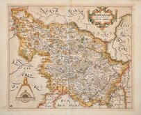
William Hole 1607 [1610]
Jan Jansson 1646
Robert Morden 1695
Robert Morden 1695 [1730]
Emanuel Bowen 1720
Kitchin & Jefferys 1749
Emanuel Bowen 1750 [1753]
Emanuel Bowen 1750 [1763]


50x42 cm
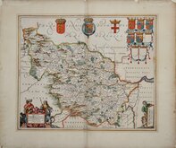
HIGHLY DECORATIVE DUTCH MAP
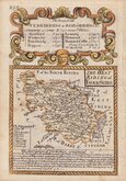
DUCATUS EBORACENSIS PARS OCCIDENTALIS; THE WESTRIDING OF YORKE SHIRE.
Copper engraving by Dutch engraver and publisher, Jan Jansson (1588-1664) issued in his Ioannis Ianssonii Novus Atlas from 1646. Following the publication of a volume of county maps of England and Wales by his rival mapmaker and publisher Jan Blaeu in 1645, Jansson produced his version just one year later matching the superb engraving standard of his rival Blaeu. There were a number of editions of Jansson's work in various languages between 1646 and 1667. Until 1658 the atlas was issued in four or five volumes with the British maps in the fourth volume, later editions expanded to eleven volumes. In 1681 Pieter Schenk and Gerard Valck had acquired the plates and began re-issues with their imprint as loose sheets sold separately and in 1714, 1715 and 1724 in Atlas Anglois, ou description general de l'Angleterre...
Latin text verso with page numbers 293 & 294 with register Iiiii identify this as the first issue of 1646.
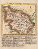
Strong paper with large margins. Centrefold split through most of the map has been repaired with slight misalignment increasing towards the bottom of the map and with some creasing and a stain at the centrefold west of Wakefield (see image 2). Small tallow stain below Barnsley. Light browning all round border from an old mount.
Despite these faults it remains an attractive map in fine hand colour from the first edtion.
Ref. Whitaker Printed Maps of Yorkshire [89]
Quick Links


Yorkshire North Riding

Whole of Yorkshire
×