
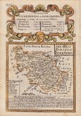
Whole of Yorkshire
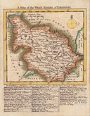
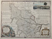
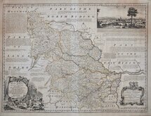
Yorkshire West Riding
( Page 1 of 3 )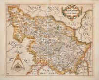
William Hole 1607 [1610]
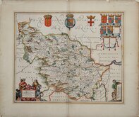
Jan Jansson 1646
Robert Morden 1695
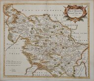
Robert Morden 1695 [1730]
Emanuel Bowen 1720
Kitchin & Jefferys 1749
Emanuel Bowen 1750 [1753]
Emanuel Bowen 1750 [1763]


25x20 cm
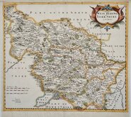
"DUKE OF YORK" SERIES
A New MAP of the WEST RIDING of YORK SHIRE Drawn from the best Authorities. By Tho''s Kitchin Geog''r Engraver to H.R.H. the Duke of York.
Copper engraving by Thomas Kitchin first published in England Illustrated, or, a compendium of natural history, geography, topography… London, R. & J. Dodsley, 1764. [1763]
Thomas Kitchin (1719-1784), one of the foremost engravers of his time, was apprenticed to Emanuel Bowen in 1732 and married his daughter, Sarah, at the end of his apprenticeship in 1739. His works include the map of Scotland by Elphinstone, maps for Geographia Scotiae, the London Magazine and The Large English Atlas, working with his father in law, Emanuel Bowen.
Robert Dodsley, the publisher of the maps, often known as The Duke of York series after the dedication in the title of each map, took his younger brother, James into partnership by 1755 and together published England Illustrated in December 1763, post-dated 1764. The work was re-issued in monthly parts early in 1764. Robert Dodsley died on 23rd September but publication of the monthly parts continued until completion on 1st January 1765. The maps appeared once more in 1765 in an atlas publication without text under the title Kitchen's (sic) English Atlas; Or, A Compleat Set of Maps Of All The Counties of England and Wales…By Thomas Kitchen, Geographer to his Royal Highness the Duke of York. London: Printed for J. Dodsley, in Pall-Mall. The maps remained unchanged in all issues.
Light spotting. A good example in good hand colour.
Ref. Whitaker Printed Maps of Yorkshire [224]
Quick Links


Yorkshire East Riding

Yorkshire North Riding
×