
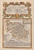
Yorkshire North Riding
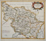
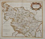
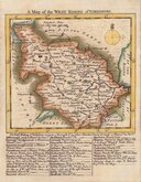
Yorkshire West Riding
( Page 1 of 3 )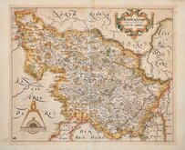
William Hole 1607 [1610]
Jan Jansson 1646
Robert Morden 1695
Robert Morden 1695 [1730]
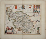
Emanuel Bowen 1720
Kitchin & Jefferys 1749
Emanuel Bowen 1750 [1753]
Emanuel Bowen 1750 [1763]


24x18 cm
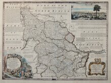
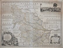
STEEL ENGRAVING WITH VIGNETTE OF WAKEFIELD SCHOOL.
WEST RIDING OF YORKSHIRE
Drawn by G Kemp, Land surveyor, Leeds. | Engraved by Ja.s Neele Burleigh Str.Strand.
Published by Arch.d Fullarton & C.o Glasgow.
First published in Bell's New and Comprehensive Gazetteer in 1833. The text for the gazetteer was largely copied from Lewis' Topographical Dictionary of 1831 and in 1839 Lewis obtained an injunction against Bell for plagiarism and the work was withdrawn. Archibald Fullarton, the publisher of Bell's Gazetteer republished the maps with new text in The Parliamentary Gazetteer from 1840 until 1849. The engraving work was shared between Gray & Son, James Neele and Robert Scott with most maps derived from those by Sidney Hall in an earlier topographical dictionary, John Gorton's Topographical Dictionary of Great Britain and Ireland published in 1831.
George Kemp (fl.1823-1843) surveyor of London and Leeds, drew the three maps of the Yorkshire Ridings for this series and each were engraved on steel by James Neele (1791-1868) engraver, copperplate printer and lithographer, son of engraver Samuel John Neele (1758-1824).
Vignette of Wakefield School.
The first state of the plate without the addition of railways published from 1833 to 1840. Folds as issued, right fold a little prominent otherwise a very good hand coloured example.
Quick Links


Whole of Yorkshire

Yorkshire East Riding
×