
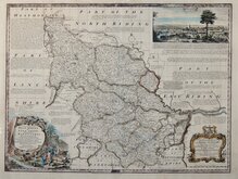
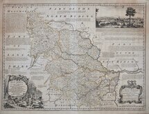
Yorkshire North Riding
Yorkshire West Riding
( Page 1 of 3 )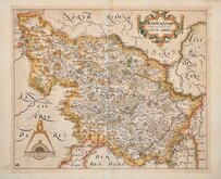
William Hole 1607 [1610]
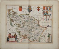
Jan Jansson 1646
Robert Morden 1695
Robert Morden 1695 [1730]
Emanuel Bowen 1720
Kitchin & Jefferys 1749
Emanuel Bowen 1750 [1753]
Emanuel Bowen 1750 [1763]


23x19 cm
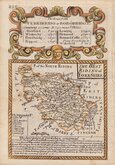
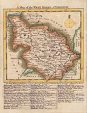
PAIR OF MAPS. UNCOMMON. FROM "THE UNIVERSAL MAGAZINE..."
Pair of maps, both titled and signed:
PART OF THE WEST RIDING OF YORKSHIRE
Engraved by B.Baker Islington.
Noted on the maps:
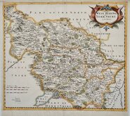
NORTH PART of the WEST RIDING
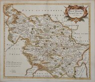
SOUTH PART of the WEST RIDING
Copper engravings by Benjamin Baker (1766-1841) born in London, the third son of Edward Baker (1730-1797) mathematical instrument maker of Fetter Lane, he was apprenticed to a watchmaker, Thomas Beresford but turned over to mapmaker, engraver and globemaker, William Palmer in 1782. He became principal engraver to The Ordnance survey in 1804.
The maps were prepared for publication in The Universal Magazine of Knowledge and Pleasure..., appearing in the issues between 1791-1797, published by W. Bent. This was the second series of county maps produced in the magazine, the first series engraved by by Emanuel Bowen, Thomas Kitchin and others were published between 1747-1766 by John Hinton. Baker's maps were based on the 'quarto' maps of John Cary published from 1787.
They were later published unchanged in Maps of the Several Counties and Shires in England…Darton and Harvey, 1804. The firm of Laurie & Whittle acquired the plates and made a number of revisions, including a compass rose behind the title and their imprint, publishing them in Laurie & Whittle's New and Improved English Atlas… 1807 & 1816.
From the first issue published in The Universal Magazine...1796. Folds as issued. Some additional creasing to the north sheet. Browning to paper edges, neat hand colour. Uncommon.
Quick Links


Whole of Yorkshire

Yorkshire East Riding
×