
Kent Maps
Sussex Maps
( Page 1 of 4 )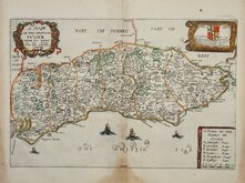
Richard Blome 1673
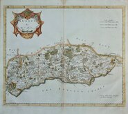
Robert Morden 1695
Emanuel Bowen 1720
Thomas Read 1744 [1769]
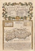
Thomas Kitchin 1763
John Cary 1787 [1808]
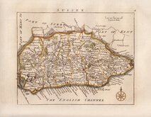
Robert Butters 1803
Charles Cooke 1810


25x20 cm
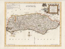
"DUKE OF YORK" SERIES
A New MAP of SUSSEX Drawn from the best Authorities By Tho,,s Kitchin Geog,,r Engraver to H.R.H. the Duke of York.
Copper engraving by Thomas Kitchin published in England Illustrated, or, a compendium of natural history, geography, topography…Robert and James Dodsley, 1764.
Thomas Kitchin (1719-1784), one of the foremost engravers of his time, was apprenticed to Emanuel Bowen in 1732 and married his daughter, Sarah, at the end of his apprenticeship in 1739. His works include the map of Scotland by Elphinstone, maps for Geographia Scotiae, the London Magazine and The Large English Atlas working with his father in law Emanuel Bowen.
Robert Dodsley, the publisher of this series, often known as The Duke of Yorkseries after the dedication in the title of each map, took his younger brother, James into partnership by 1755 and together published England Illustrated in December 1763 post-dated 1764.
The work was re-issued in monthly parts early in 1764. Robert Dodsley died on 23rd September but the parts issues continued until completion on 1st January 1765. The maps appeared once more in 1765 in an atlas publication without text under the title Kitchen's (sic) English Atlas; Or, A Compleat Set of Maps Of All The Counties of England and Wales…By Thomas Kitchen, Geographer to his Royal Highness the Duke of York. London: Printed for J. Dodsley, in Pall-Mall.
Good example in neat later hand colour.
Ref. Kingsley Printed Maps of Sussex 42
Quick Links


Hampshire Maps

Surrey Maps
×