
Surrey Maps
Sussex Maps
( Page 1 of 4 )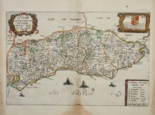
Richard Blome 1673
Robert Morden 1695
Emanuel Bowen 1720
Thomas Read 1744 [1769]
Thomas Kitchin 1763
John Cary 1787 [1808]
Robert Butters 1803
Charles Cooke 1810


31x21 cm
NEAT HAND COLOUR
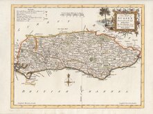
A MAPP OF THE COVNTY OF SVSSEX WITH ITS RAPES BY RIC BLOME BY HIS MAty ESPECIALL COMAND
Dedication: To y.e R.t Hon.ble Charles Lord Buckhurst one of ye Gentlemen of his Maty: Bedchamber & Son & heire to ye R.t Hon.ebl Ric. Earle of Dorset Baron Buckhurst Lord Leiutenant of this County. This Mapp is humbly dedicated by Ric. Blome.
Produced and published by Richard Blome (1635-1705) bookseller, mapseller and publisher, printer to King William III and cosmographer to Queen Anne, in Britannia: or, A Geographical Description of the Kingdoms of England, Scotland and Ireland...London, Printed by Tho. Rycroft for the Undertaker, Richard Blome. 1673.
This series of maps were produced quickly following an announcement in the press by John Ogilby of his intention to produce a new work of county maps, road maps and town plans entitled Britannia. Blomes maps are crudely engraved, typical of journeyman work, and mostly copied from those of John Speed. The printing, however was of the highest standard, being carried out by Thomas Roycroft, printer to King Charles II. Richard Blome shamelessly used the same title announced by John Ogilby for his work, commencing publication in 1673.
The edition was probably on sale for four years. There was a re-issue of 1677 made up by John Wright from remaindered sheets.
Browning to paper edges and bottom centreflold, but with good margins, still a good hand coloured example.
Ref. Kingsley Printed Maps of Sussex 15
Quick Links


Kent Maps

Hampshire Maps
×