
Hampshire Maps
Sussex Maps
( Page 1 of 4 )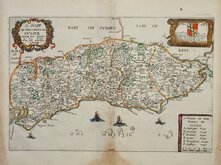
Richard Blome 1673
Robert Morden 1695
Emanuel Bowen 1720
Thomas Read 1744 [1769]
Thomas Kitchin 1763
John Cary 1787 [1808]
Robert Butters 1803
Charles Cooke 1810


12x18 cm
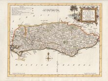
FROM "OWEN & BOWEN" ROAD BOOK BRITANNIA DEPICTA.
A MAP OF SUSSEX
The map set below the title for the Road from London to Arundel.
Copper engraving by Emanuel Bowen published in the pocket road book Britannia Depicta by Thomas Bowles from 1720. This was the first truly pocket sized road book for the traveller based on the surveys of John Ogilby published in large folio format 45 years earlier in 1675. It was last and most successful of four separate schemes to produce such a work within the space of two years, running to over fifteen editions until 1764. The other road books were by Thomas Gardner and John Senex. The work by Herman Moll was not completed. The books by Gardner and Senex were simple reductions of John Ogilby's plates but the plates for Britannia Depicta included a wealth of historical, topographical and informative notes compiled by John Owen, arms of major towns and worthies and a set of small county maps. The plates were printed on both sides of the paper, reducing the weight of the volume. Descriptions by John Owen were engraved on the copperplate surrounding the maps and also on separate plates. The maps have become commonly known as "Owen & Bowen" maps.
The map of Sussex from an early edition in the second state with rape numbers added to the map. Final part of the road from London to Aberystwyth verso.
Fine later hand colour.
Kingsley ref. 23(ii)
Quick Links


Surrey Maps

Kent Maps
×