
Surrey Maps
Sussex Maps
( Page 1 of 4 )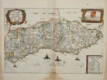
Richard Blome 1673
Robert Morden 1695
Emanuel Bowen 1720
Thomas Read 1744 [1769]
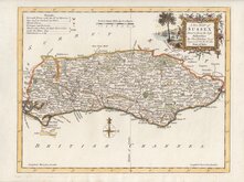
Thomas Kitchin 1763
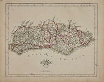
John Cary 1787 [1808]
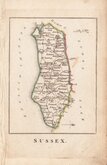
Robert Butters 1803
Charles Cooke 1810


24x18 cm
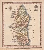
SUSSEX
Drawn by R. Creighton. | Engraved by J.& C.Walker
DRAWN AND ENGRAVED FOR LEWIS’ TOPOGRAPHICAL DICTIONARY.
Copper engraving by the firm of J & C Walker from a drawing by Roger Creighton for publication in A Topographical dictionary of England…published by Samuel Lewis and Co. from 1831. The work achieved considerable success and was re-issued many times by Lewis until 1849. During this time the maps were amended and updated to include electoral information and the rapidly expanding railway network, with most counties known in at least six different states.
Small stain in title, otherwise a good clean example in original outline hand colour depicting the poor law unions issued between 1842 & 1845.
Kingsley ref. 97(v).
Quick Links


Hampshire Maps

Kent Maps
×