
Hampshire Maps
Sussex Maps
( Page 1 of 4 )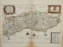
Richard Blome 1673
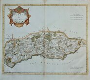
Robert Morden 1695
Emanuel Bowen 1720
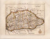
Thomas Read 1744 [1769]
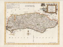
Thomas Kitchin 1763
John Cary 1787 [1808]
Robert Butters 1803
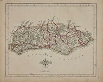
Charles Cooke 1810


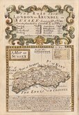
11x7 cm
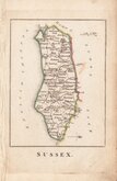
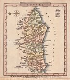
FIRST ATLAS ISSUE OF THE MINIATURE MAP LATER USED FOR REUBEN RAMBLE'S TRAVELS THROUGH THE COUNTIES OF ENGLAND. UNCOMMON.
SUSSEX
London Published by R Miller, 24, Old Fish Street.
Miniature map first issued in sets of cards c.1819 by Thomas Crabb. They were also issued as a set of cards c.1822 by Hinton, by Darton also c.1822 and by Hodgson c.1825. All these playing card issues were small and are extremely rare.
The first atlas issue was published by Robert Miller in Miller’s new miniature atlas containing a complete set of county maps… London (1821). William Darton then acquired the plates and published Darton’s new miniature atlas containing a complete set of county maps… London (1822) & (1825). The maps are best known in their final appearance for Reverend Samuel Clark’s Georgian school atlas, Reuben Ramble's Travels Through the Counties Of England in 1845 & 1850. For this publication the maps were printed by lithographic transfer with the addition of vignettes of local landmarks and industry.
This example of the map of Sussex is from the first atlas issue of 1821 published by Robert Miller and is in original hand colour.
Light stain to edges and part of sea area. Uncommon.
Ref. Kingsley Printed Maps of Sussex 81 (i).
Quick Links


Surrey Maps

Kent Maps
×