
Surrey Maps
Sussex Maps
( Page 1 of 4 )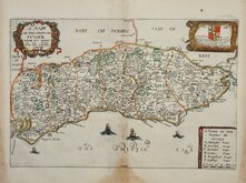
Richard Blome 1673
Robert Morden 1695
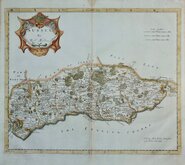
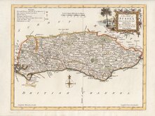
Emanuel Bowen 1720
Thomas Read 1744 [1769]
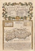
Thomas Kitchin 1763
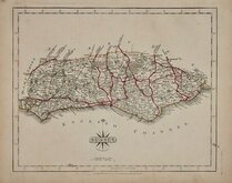
John Cary 1787 [1808]
Robert Butters 1803
Charles Cooke 1810


41x41 cm
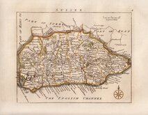
PAIR OF MAPS BOUND INTO THE HISTORY OF SUSSEX BY THOMAS HORSFIELD. INCLUDES THE TWO VOLUMES COMPLETE.
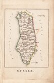
MAP OF SUSSEX.
PART I. EAST.
Drawn and Engraved by B.R.Davies, 16 George Str. Euston Squ London.
Published by J. Baxter, Lewes. Dec.r 1. 1834.
Gad & Co. Printers, London.
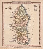
MAP OF SUSSEX.
PART II. WEST.
Drawn and Engraved by B.R.Davies, 16 George Str. Euston Squ London.
Published by J. Baxter, Lewes. Dec.r 1. 1834.
The maps include views of sections along the coast engraved vertically in the sea, 12 on the East map and 9 on the west.
The maps are recorded as having been first issued as loose sheets both lacking the printer's imprint. The first issue in the work by Thomas Horsfield included the printer's imprint on Part I East. A further issue included some minor amendments to the county boundary and the printer's imprint on Part II West and a final issue included engraver's signatures to the views.
Archival tape to the fold intersection verso of each map. Some offsetting from the views on the west map. They are both good examples and remain bound into each volume of the two volume work.
Kingsley Printed Maps of Sussex ref. 104 (ii)
The price below is for the complete two volume work which also contains 58 full page copper engravings, 80 wood engravings and numerous armorials.
For details of the book go to the listing in Antiquarian books.
Quick Links


Kent Maps

Hampshire Maps
×