
Folding Maps
Regional Maps
( Page 1 of 10 )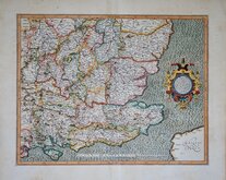
Gerard Mercator South East England 1630
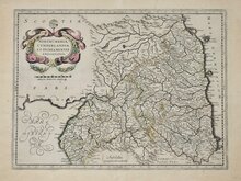
Cumberland Northumberland Durham 1639

Hertfordshire Part 1766
Essex Part Chapman and Andre 1777
Essex Part Chapman and Andre 1777
Southern Britain Zatta 1778
Kings Langley 1786
Barnet 1786

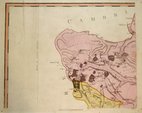
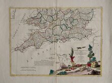
£65 Plymouth & Devonport by Moule
Ref: 3578gb
Add to
basket
Thanks,Your Product Has Been Added To Basket

27x21 cm
ENVIRONS OF PLYMOUTH & DEVONPORT
This series of decorative steel-plate engraved maps are commonly known by the author of the work in which they first appeared; Moule's English Counties Delineated. First issued from May 1830 in a series of parts, the first complete edition was published by George Virtue in 1837. Several editions followed until 1839 and the plates were extensively used thereafter by George Virtue and his son James Sprent Virtue in A Complete and Universal Dictionary of the English Language by the Rev. James Barclay until 1857. The engraving of the plates was shared between James Bingley, W. Schmollinger and John Dower. The plates underwent a number of changes including the interchanging of engraver's names in the early issues and were frequently updated to reflect the rapidly developing railway network.
Thomas Moule was born in Marylebone on January 14th 1784. He was a bookseller in Grosvenor Square between 1816 and 1822. He was inspector of 'blind letters' in the General Post Office for forty years and also held the office of Chamber-keeper of the Lord Chamberlain's department which gave him an official residence in the stable yard, St. James a lace where he spent the later years of his life and died on January 14th 1851. During his life Thomas Moule wrote a number of books on heraldry and antiquities, these interests being reflected in the decorative neo-gothic elements and coats of arms that surround his maps. It was this return to the decorative armorial cartography of the 17th and 18th centuries that contributed to the commercial success of his maps that remain popular to this day.
Fine hand coloured example of the Environs of Plymouth and Devonport with vignette of Plymouth Citadel and Arms of Plymouth. Small margins all round but sufficient for mounting and framing. A plate number was added to most maps in the series when published in the 1842 edition of Barclay's Dictionary, this map was probably issued at this time.
Quick Links


Road Maps
Town Plans
×