
Folding Maps
Regional Maps
( Page 4 of 10 )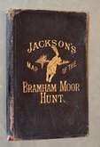
Jacksons Bramham Moor Hunt 1895

Farnborough 1906
South of Keswick Cumberland 1908
Long Valley Aldershot 1913
South East England 1930
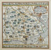
New Forest Alfred Taylor 1930
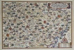
Alfred Taylor Pratts Eastern Counties and Midlands 1932
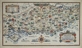
Alfred Taylor Pratts South Coast 1932


£60 Jacksons Bramham Moor Hunt
Ref: 6464tv
Add to
basket
Thanks,Your Product Has Been Added To Basket

95x71 cm
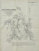
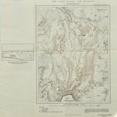
JACKSON'S MAP OF THE BRAMHAM MOOR HUNT.
MARTIN, HOOD & LARKIN, LITH. TRAFALGAR HOUSE, GT. NEWPORT ST. LONDON. W.C.
PUBLISHED BY RICHARD JACKSON, 16 & 17 COMMERCIAL STREET, LEEDS.
Lithograph colour printed map dissected into 32 sections and pasted on linen in black calf wallet with gilt title and running fox vignette to front.
Various advertisements verso.
Map covers the area from Leeds & Otley in the south west, to Pateley Bridge in the north west, to York and to Selby in the south east.
Overprinted in colours to show the extent of the hunt (yellow bordered in red), the hunt meets (red dots), coverts (green), andjacent hunt areas (blue), adjacent hunt meets (blue dots), Turnpike roads (brown), Rivers, (blue).
Wallet worn and frayed at edges. Ink ownership inscription and some pencilled notes about hunt meetings to back of linen.
Map in good condition. First edition. n.d. [c.1895]
Quick Links

Town Plans

Road Maps
×