
Essex Maps
Kent Maps
( Page 1 of 3 )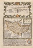
Emanuel Bowen 1720
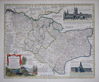
Emanuel Bowen 1763 [c.1777]
Joseph Ellis 1773
Eugene Henry Fricx 1777

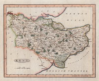
John Cary 1789 [1791]
Benjamin Baker 1792
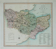
Charles Smith 1801 [1804]
Robert Butters 1803


9x14 cm
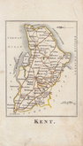
CARY'S MINIATURE SERIES. NORTH TO THE RIGHT.
KENT
By J.Cary | Engraver
London. Published Sepr. 1.1792 by J.Cary Engraver No 181 Strand
Miniature map from Cary's Travellers Companion. First published in 1789, this travellers book was popular, running to several editions until at least 1801 and with re-engraved versions of the maps in 1806 and 1822, the work continued to be issued by the Cary firm until 1835. Their final appearance was published by G.F.Crutchley in his Railroad companion to England and Wales...in 1862.
This example of the map of Kent is engraved with North to the right. Dated 1792, it is from the third state of the first engraved plate published in 1791.
Map of Huntingdonshire verso.
Original hand colour.
Quick Links


Sussex Maps

Surrey Maps
×