
Dorset Maps
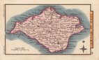
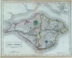
Isle of Wight
( Page 1 of 2 )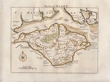
Thomas Read 1769
John Seller 1784
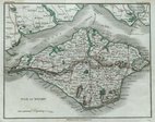
Cole & Roper 1805
Nathaniel Coltman 1809
Sidney Hall 1820
John Cary 1821
Joshua Archer 1833
Sidney Hall 1834


23x18 cm
ISLE OF WIGHT
Engraved by J.Roper, from a Drawing by G.Cole.| to accompany the Beauties of England & Wales.
London: Published for the Proprietors, by Vernor, Hood & Sharpe, Poultry, Octr.1.st1805.
Engraved by John Roper (1771-1810), a London engraver and copperplate printer trading from New Street Square from 1797 until his death in 1810. His widow, Mary Roper, continued the business at the same address until at least 1846. This series of maps, most drawn by G[eorge?] Cole, were intended to accompany The Beauties of England and Wales. The maps were not actually published with this work but first issued in parts as a separate series between 1804 and 1810 and first appearing in atlas form in The British Atlas published by Vernor Hood & Sharpe (& nine other publishers) in 1810. The maps were re-issued in several publications including Dugdale's Curiosities of Great Britain until 1843. Their final appearance was by lithographic transfer in Collins' railway and pedestrian atlas… published by Darton and Co. in 1858.
Good example from the first edition in original hand colour.
Quick Links

Wiltshire Maps

Hampshire Maps
×