
Gloucestershire Maps
Wiltshire Maps
( Page 1 of 3 )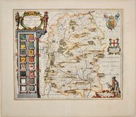
Jan Blaeu 1645
Owen & Bowen 1720
Thomas Kitchin 1751 [c.1786]
Thomas Kitchin 1763
Thomas Bowen 1767 [c.1770]
Benjamin Baker 1795 [c.1807]
Robert Butters 1803
John Cary 1808 [1809]


50x41 cm
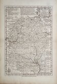
DECORATIVE 17TH C. DUTCH MAP
WILTONIA sive COMITATUS WILTONI:ENSIS; . Anglia WIL SHIRE.
Copper engraving by Jan Blaeu (1596-1673) the son of William Janszoon Blaeu (1571-1638), founder of the Dutch publishing house. The county maps of England and Wales appeared in the fourth volume in 1645 of their world atlas, Theatrum Orbis Terrarum which commenced publication with the first volume in 1630 and eventually expanded to 12 volumes. The maps were closely copied from John Speed and the text verso translated into various languages from William Camden's Britannia. The production of the maps was of the highest quality with consistently fine and uniform engraving embellished with decorative title cartouches and armorial bearings, high quality printing from Blaeu's own printing house using the finest quality rag paper and usually completed with hand colouring carried out within Blaeu's own workshops. The atlases containing the English county maps were published from 1645 until 1667, the maps remained unaltered throughout publication. The typeset text printed on the reverse of the maps was re-set for each edition and is our aid to the identification of a loose map. A fire at Blaeu's printing house destroyed most of the plates in 1672 and Jan Blaeu died the following year effectively ending the Blaeu publishing dynasty.
A fine example of a very decorative map.
Dutch text verso.
SPECIAL OFFER MOUNT OPTION AVAILABLE AT CHECKOUT FOR UK POSTAGE
Quick Links


Hampshire Maps

Berkshire Maps
×