
Wiltshire Maps
Dorset Maps
( Page 1 of 3 )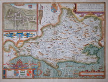
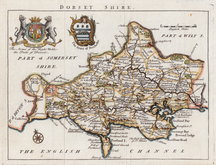
John Speed 1610 [1676]
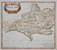
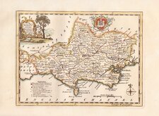
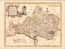
Robert Morden 1695
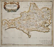
Robert Morden 1695
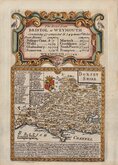
Owen & Bowen 1720
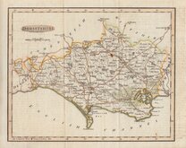
Robert Walker 1748
Thomas Kitchin 1750 [1786]
Thomas Kitchin 1764
Benjamin Baker 1791


52x40 cm
BASSETT & CHISWELL LOOSE SHEET EDITION WITH NO TEXT VERSO.
DORSETSHYRE
With the Shyre-towne Dorchester described, as also the Armes of such noble families as have bene honored with the Titles there of since the Normans Conquest to this present Anno 1662
Are to be Sold by Thomas Bassett in Fleet Street, and Richard Chiswell in St. Pauls Churchyard.
John Speed (1552-1629), born in Cheshire, was a Tailor, becoming a member of the Worshipful Company of Merchant Taylors in 1580. He became interested in History and antiquities and became a member of the Society of Antiquaries and friend of William Camden. In 1611 he published his History of Great Britaine followed by his Theatre of the Empire of Great Britaine the following year. The Theatre was designed as the topographical section to his History and the inclusion of county maps with inset town plans has ensured Speed's name will be remembered. The maps were designed and engraved by Jodocus Hondius in Amsterdam from materials and instructions sent to him by Speed. Speed's main cartographical contribution was the town plans, Speed claiming authorship to those that include a scale of paces "by mine owne travails". The county maps are based on the surveys of Christopher Saxton and John Norden. The inclusion of the internal administrative divisions of the counties was a new innovation by Speed perpetuated in most county maps that followed for the next 300 years. On 29th April 1608 George Humble obtained the rights to print and sell the atlas for 21 years but publication did not actually start until 1611. Publication of John Speed's maps continued by various publishers until at least 1770, a publication period of 160 years.
This map of Dorset, with the imprint of Bassett & Chiswell has no text verso and was issued as loose sheets sold separately from 1676 by Bassett & Chiswell.
Some old colour with later additions. 2 small holes where verdigris in the original green pigment has affected the paper but otherwise in good condition on strong paper with good margins.
Quick Links


Hampshire Maps

Somerset Maps
×