
Lancashire Maps
Cheshire Maps
( Page 1 of 3 )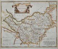
Robert Morden 1695
Emanuel Bowen 1720
Joseph Ellis 1765 [1773]
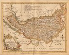
John Cary 1789 [1805]
Benjamin Baker 1791
Robert Butters 1803
Charles Smith 1804
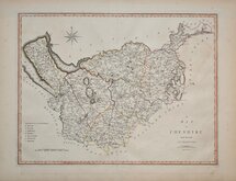
Henry Cooper 1808


9x13 cm
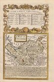
RARE "UPSIDE-DOWN' SERIES
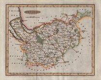
CHESHIRE
The engraver or engravers of this series of maps are unknown and the maps are known by the first publisher, Robert Butters, a Fleet Street printer, who issued them in An Atlas of England... in 1803. They are also referred to as the "upside-down series" as the England map and many of the county maps are engraved with North to the bottom of the page. In fact, the county maps are variously orientated with North to the top, left, right or bottom of the page. The work was possibly intended for school use and the odd orientation of the maps may have been done to appeal to young minds. This represented Robert Butters' only serious venture into cartography but unlike the huge success of John Cary's publication The Traveller's Companion, on which these maps were based, Butter's publication was limited to this single issue. John Hatchard acquired the plates later the same year issuing them in a two-volume work The Picture of England 1803, and 1804. The publications were small and only a single copy of the Hatchard 1803 edition has been found.
This map of Cheshire lacks a North point but is orientated with North to the left.
Very good example of a rare miniature map in original hand colour.
Quick Links


Road Maps

Staffordshire Maps
×