
Leicestershire Maps
Warwickshire Maps
( Page 1 of 3 )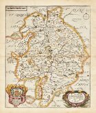
Richard Blome 1673
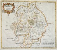
Robert Morden 1695
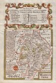
Emanuel Bowen 1720
Emanuel & Thomas Bowen 1767 [c.1770]
John Cary 1787 [c.1793]
John Haywood 1788
Edward Noble 1789 [c.1805]
Robert Butters 1803


20x25 cm
FIRST EDITION
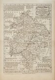
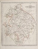
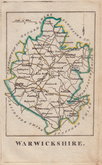
WARWICKSHIRE
Neele sculpt. Strand.
Published by J. Robins & Co. Albion Press London January 1st. 1818.
Drawn and engraved by Samuel John Neele (1758-1824), this series were based on John Cary's 'quarto' maps of 1793. The early publication is complex with loose issues and parts issues for many counties from about 1812. The first main publication containing the complete set of county maps was The New British Traveller; or, modern panorama of England and Wales...By James Dugdale... published about 1819 by J & J Cundee. The maps appeared in three further issues with the imprint of J. Robins & Co. under various titles; Robins’s Atlas of England and Wales…1819, The New British Traveller…1819, A topographical and historical description of the county of Warwick…by William Smith F.R.S.A.…1829 and A new & compendious history of the county of Warwick...by William Smith F.R.S.A.…1830.
Samuel John Neele was a prolific engraver working from Russell Court from 1781 and 352 Strand from 1785-1824. He traded with his younger brother George Neele as “S.& G. Neele” 1826-1824 and with his son James Neele as “Neele & Son” 1816-1824.
From the first state with Robins' imprint dated 1818. [pub.1819 & 1820]
Small margins as usual with this publication.
Ref. Harvey & Thorpe Printed Maps of Warwickshire 68 (i)
Quick Links


Worcestershire Maps

Staffordshire Maps
×