
Worcestershire Maps
Warwickshire Maps
( Page 1 of 3 )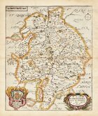
Richard Blome 1673
Robert Morden 1695
Emanuel Bowen 1720
Emanuel & Thomas Bowen 1767 [c.1770]
John Cary 1787 [c.1793]
John Haywood 1788
Edward Noble 1789 [c.1805]
Robert Butters 1803


43x36 cm
FIRST MAP OF THE COUNTY TO SHOW LONGITUDE FROM LONDON.
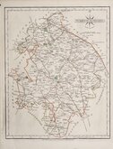
WARWICK SHIRE By Rob.t Morden.
Sold by Abel Swale, Awnsham & Iohn Churchil.
Copper engraving produced by Robert Morden for publication in Edmund Gibson's translation of William Camden's Britannia first published by Abel Swale and Awnsham & John Churchill in 1695.
This is the first series of maps to mark longitude in minutes of time from London (top border) as well as in degrees (bottom border). Minutes of time was useful during a period when time was not yet standardised across the country. For most counties longitude is based on the meridian of St. Paul's, London. For many maps in the series they were the first folio county maps to show roads, Morden making use of the survey and strip road maps of John Ogilby published in his road book, also entitled Britannia, in 1675. It was Morden's miniature maps produced on a set of playing cards in 1676 which were the first complete set of county maps to include roads. Morden did not however, adopt John Ogilby's standardisation of measure for the mile at 1760 yards preferring the somewhat arbitrary method of including three scales according to varying local measurement, of 'Great', 'Middle' and 'Small' miles. Gibson's Britannia was republished in 1722, 1730, 1753 and, finally in 1772. The maps were updated for the 1722 edition, mostly with changes to place name spellings and the plates were reworked for the 1753 edition due to wear caused by the printing process.
Light diagonal crease bottom left corner but still a good example from the 1695 edition in good later hand colour.
Ref. Harvey & Thorpe Printed Maps of Warwickshire 18.
Quick Links


Leicestershire Maps

Staffordshire Maps
×