
Worcestershire Maps
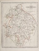
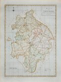
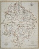
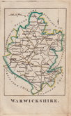
Warwickshire Maps
( Page 1 of 3 )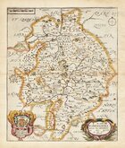
Richard Blome 1673
Robert Morden 1695
Emanuel Bowen 1720
Emanuel & Thomas Bowen 1767 [c.1770]
John Cary 1787 [c.1793]
John Haywood 1788
Edward Noble 1789 [c.1805]
Robert Butters 1803


23x34 cm
SCARCE. FROM "ATLAS ANGLICANUS".
WARWICK SHIRE, Divided into HUNDREDS, Exhibiting the City, County, Borough and Market Towns &c. with Historical Extracts, relative to its Natural Produce, Trade & Manufactures. Describing also the Church Livings; with Improvements not inserted in any other Half Sheet County Maps Extant. By Eman. Bowen, Geogr. to His late Majesty, & Thos. Bowen.
Printed for T. Kitchin, at No.59 Holborn Hill, London.
First published in Atlas Anglicanus...By the late Emanuel Bowen, geographer to His Majesty George IId. and Thomas Bowen. London T. Kitchin [1767].
The maps were based on the large folio maps produced for the Large English Atlas by Thomas Kitchin and Emanuel Bowen from about 1749. Various publishers were involved in the troubled and expensive production of the work and the subsequent productions of smaller maps in the Royal English Atlas and Atlas Anglicanus were attempts at recouping some of the expenses incurred for the original surveys and publication. Neither of the smaller derivatives achieved the sales success made by the Large English Atlas.
There were three issues of Atlas Anglicanus in 1767, 1770 and 1777. The plates were then acquired by Thomas Bowles who erased the decorative rococo title cartouche, replacing it with a simple oval title panel, publishing them in his New Medium Atlas in 1785 with individual county maps being offered for sale until at least 1798.
Emanuel Bowen’s son, Thomas, worked with him on this, his final work, the publication of which coincided with Emanuel’s death in 1767.
Fine uncoloured example, with the imprint of Thomas Kitchin, it was published in the 1770 or 1777 issue of Atlas Anglicanus. Library stamp verso for Birkenhead free Libraries.
A scarce map.
Ref. Harvey and Thorpe Printed Maps of Warwickshire 41 (ii)
SPECIAL OFFER MOUNT OPTION AVAILABLE AT CHECKOUT FOR UK POSTAGE
Quick Links


Staffordshire Maps

Leicestershire Maps
×