
Leicestershire Maps
Warwickshire Maps
( Page 1 of 3 )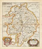
Richard Blome 1673
Robert Morden 1695
Emanuel Bowen 1720
Emanuel & Thomas Bowen 1767 [c.1770]
John Cary 1787 [c.1793]
John Haywood 1788
Edward Noble 1789 [c.1805]
Robert Butters 1803


26x31 cm
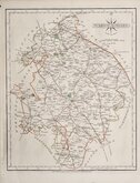
BLOME'S LARGE SERIES. NEAT HAND COLOUR.
A MAP OF WARWICKSHIRE, WITH ITS HUNDREDS, BY RIC: BLOME BY HIS MA.TYS COMAND.
Produced and published by Richard Blome (1635-1705) bookseller, mapseller and publisher, printer to King William III, and cosmographer to Queen Anne, in Britannia: or, A Geographical Description of the Kingdoms of England, Scotland and Ireland...London, Printed by Tho. Rycroft for the undertaker, Richard Blome. 1673.
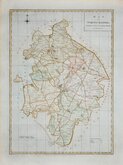
This series of maps were produced quickly, following an announcement in the press by John Ogilby of his intention to produce a new work of county maps, road maps and town plans entitled Britannia. Richard Blome shamelessly used the same title announced by John Ogilby for his work, and commenced publication in 1673. Blomes maps are crudely engraved, typical of journeyman work, and mostly copied from those of John Speed, containing no new information. The printing, however, was of the highest standard, being carried out by Thomas Roycroft, printer to King Charles II.
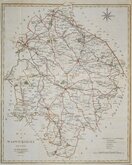
The publication was probably on sale for four years. There was a re-issue of 1677 made up by John Wright from remaindered sheets.
Toning to paper edges and centrefold but with good margins, the map is largely unaffected and is a good impression in fine hand colour.
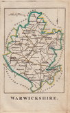
Ref. Harvey & Thorpe Printed Maps of Warwickshire 14 (iii).
Quick Links


Worcestershire Maps

Staffordshire Maps
×