
Leicestershire Maps
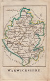
Warwickshire Maps
( Page 1 of 3 )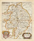
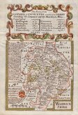
Richard Blome 1673
Robert Morden 1695
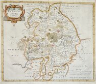
Emanuel Bowen 1720
Emanuel & Thomas Bowen 1767 [c.1770]
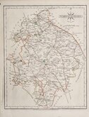
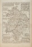
John Cary 1787 [c.1793]
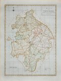
John Haywood 1788
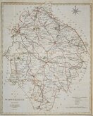
Edward Noble 1789 [c.1805]
Robert Butters 1803


33x46 cm
LARGE CLEAR MAP. NEAT HAND COLOUR.
A MAP OF WARWICKSHIRE, ENGRAVED FROM AN ACTUAL SURVEY, with Improvements.
Engraved for J. Harrison No.115, Newgate Street, as the Act directs, 18 July. 1788. Sudlow Sc.
This series of county maps were issued at erratic intervals over a four year period bearing dates between 1787 and 1789. The atlas Maps Of The English Counties… was first issued in 1791 by J. Harrison and remained on sale for several years but appears to have not sold well as various reductions in price are recorded.
The border is divided and numbered at 5' intervals with a graticule over the map.
Good hand coloured example with generous margins
Ref. Harvey & Thorpe Printed Maps of Warwickshire 45.
Quick Links


Worcestershire Maps

Staffordshire Maps
×