
Leicestershire Maps
Warwickshire Maps
( Page 1 of 3 )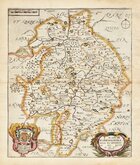
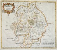
Richard Blome 1673
Robert Morden 1695
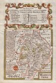
Emanuel Bowen 1720
Emanuel & Thomas Bowen 1767 [c.1770]
John Cary 1787 [c.1793]
John Haywood 1788
Edward Noble 1789 [c.1805]
Robert Butters 1803


20x24 cm
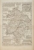
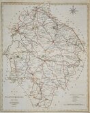
STEEL ENGRAVING. VIGNETTE OF COVENTRY.
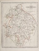
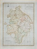
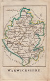
WARWICKSHIRE
Published. by Archd. Fullarton & Co.
Steel engraving by Robert Scott first published in Bell's New and Comprehensive Gazetteer in 1834. The text for the gazetteer was largely copied from Lewis' Topographical Dictionary of 1831 and in 1839 Lewis obtained an injunction against Bell for plagiarism and the work was withdrawn. Archibald Fullarton, the publisher of Bell's Gazetteer republished the maps with new text in The Parliamentary Gazetteer from 1840 until 1849. The engraving work was shared between Gray & Son, James Neele and Robert Scott with most maps copied from those by Sidney Hall in an earlier topographical dictionary, John Gorton's Topographical Dictionary of Great Britain and Ireland published in 1831.
The map is unsigned by the engraver but the vignette of Coventry is signed by Robert Scott and the design of the compass rose is as other maps signed by him.
Robert Scott (1771-1841), born at Lanark 13 Nov 1771, the son of Robert Scott, a skinner and his wife Grizzell. He was apprenticed to Edinburgh engraver Alexander Robertson. He had premises in Edinburgh from 1797 to 1840, his Parliament Square premises occupied from 1810, were destroyed by fire in 1824. He died in January 1841 reputed to be the finest Scottish engraver of his time. Two of his sons, David Scott (1806-1849) and William Bell Scott (1811-1890) became notable artists.
This example with revised imprint was published by Fullarton & Co. in 1845 & 1846. Light occasional spotting in margins outside plate mark. Neat hand colour.
Ref. Harvey & Thorpe Printed Maps of Warwickshire 92(iii).
Quick Links


Staffordshire Maps

Worcestershire Maps
×