
Leicestershire Maps
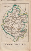
Warwickshire Maps
( Page 1 of 3 )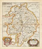
Richard Blome 1673
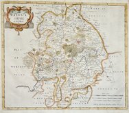
Robert Morden 1695
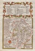
Emanuel Bowen 1720
Emanuel & Thomas Bowen 1767 [c.1770]
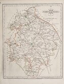
John Cary 1787 [c.1793]
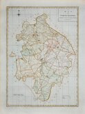
John Haywood 1788
Edward Noble 1789 [c.1805]
Robert Butters 1803


21x28 cm
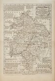
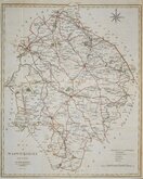
RE-ENGRAVED EDITION. FINE ORIGINAL COLOUR. WITH TEXT.
WARWICKSHIRE
By JOHN CARY Engraver.
London: Published July 1. 1809 by J.Cary Engraver & Map-seller Strand.
Copper engraving by John Cary. This series of maps, commonly known as his "quarto" series, were published in Cary's New and Correct English Atlas and were justifiably popular, running to many editions from 1787 until about 1804. Re-engraved plates extended the life of the series from 1808 to 1843 and lithographic transfers from the plates by later publishers continued publication until about 1876 - a life of nearly 90 years.
John Cary (1755-1835) born 23rd February at Corsley in Wiltshire, the son of George, a maltster and churchwarden, and Mary Cary. He came to London and was apprenticed to mapmaker, engraver and globemaker, William Palmer (1739-1812) from 7th March 1770 to 4th March 1778. He married Ann Jackson 21st June 1779 at St Bride’s, Fleet Street. Three of his brothers also came to London; George Cary (1753-1830) haberdasher, Francis Cary (1756-1836) engraver, and William Cary (1759-1825) optical and mathematical instrument-maker and globemaker. John Cary was appointed Surveyor of Roads to the General Post Office in 1794. He won the Gold Medal of the Royal Society of Arts 1804 for his large scale map of Cardiganshire. Cary’s two sons George (1787-1859) and John (1791-1852) were associated with him in his business and after the Strand premises burned down on 17th Jan 1820, continued his business from 86, St James, John Cary himself acquiring a house on the Kings Road Chelsea. He died at Mortlake on 16th August 1835 leaving freeholds of two properties in the Strand to his sons and the Kings Road property to his daughter.
This example, in fine original hand colour, of the map of Warwickshire, is from the re-engraved plate published in Cary's New and Correct English Atlas of 1809.
Includes original page of typeset text description of the county.
Ref. Harvey & Thorpe Printed Maps of Warwickshire. 61(i)
Quick Links


Worcestershire Maps

Staffordshire Maps
×