
Worcestershire Maps
Warwickshire Maps
( Page 1 of 3 )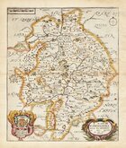
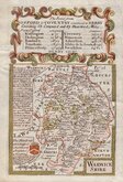
Richard Blome 1673
Robert Morden 1695
Emanuel Bowen 1720
Emanuel & Thomas Bowen 1767 [c.1770]
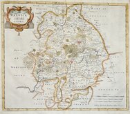
John Cary 1787 [c.1793]
John Haywood 1788
Edward Noble 1789 [c.1805]
Robert Butters 1803


21x26 cm
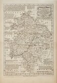
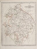
HIGHLY DECORATIVE VICTORIAN MAP
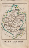
WARWICKSHIRE
This series of decorative steel-plate engraved maps are commonly known by the author of the work in which they first appeared; Moule's English Counties Delineated. First issued from May 1830 in a series of parts, the first complete edition was published by George Virtue in 1837. Several editions followed until 1839 and the plates were then used by George Virtue and his son James Sprent Virtue in A Complete and Universal Dictionary of the English Language by the Rev. James Barclay until 1857. The engraving of the plates was shared between James Bingley, William Schmollinger and John Dower. The plates underwent a number of changes, including the unexplained interchanging of engraver's names in the early issues, and were frequently updated to reflect the rapidly developing railway network.
Thomas Moule was born in Marylebone on January 14th 1784. He was a bookseller in Grosvenor Square between 1816 and 1822. He was inspector of 'blind letters' in the General Post Office for forty years and also held the office of Chamber-keeper of the Lord Chamberlain's department which gave him an official residence in the stable yard, St. James a lace where he spent the later years of his life and died on January 14th 1851. During his life Thomas Moule wrote a number of books on heraldry and antiquities, these interests being reflected in the decorative neo-gothic elements and coats of arms that surround his maps. It was this return to the decorative armorial cartography of the 17th and 18th centuries that contributed to the commercial success of his maps that remain popular to this day.
The engraver of this Warwickshire map, William Francis Schmollinger (c.1811-1869), was recorded as keeper of the Grasshopper tavern, Gracechurch Street 1841-1856. He was in a publishing partnership with Francis Roxburgh and James Bingley in 1833 which led to Bingley being imprisoned for debt and a court case between Roxburgh and Schmollinger. He was granted a patent in 1853 for “improvements in the means of converting reciprocating or rectilinear motion into rotary motion”. He was declared bankrupt in May 1956 and died aged 58 at Camberwell in 1869.
Final state of the plate published in 1850 & 1852.
Good margins. Fine hand colour.
Harvey and Thorpe Printed Maps of Warwickshire ref. 95(vii).
Quick Links


Staffordshire Maps

Leicestershire Maps
×