
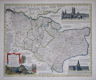
Sussex Maps
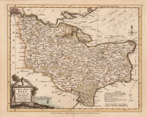
Kent Maps
( Page 1 of 3 )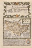
Emanuel Bowen 1720
Emanuel Bowen 1763 [c.1777]
Joseph Ellis 1773
Eugene Henry Fricx 1777

John Cary 1789 [1791]
Benjamin Baker 1792
Charles Smith 1801 [1804]
Robert Butters 1803


15x9 cm
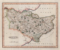
CARY'S MINIATURE SERIES. RE-ENGRAVED VERSION.
KENT
London. Published by G.& J.Cary. No.86 St.James's Str.
A re-engraved and revised version of of the map issued by John Cary in 1806 which in turn, was a re-engraved version of his 1789 map. All were issued under the title of Cary's Traveller's Companion, a highly successful work necessitating the re-engraving of worn plates to continue publication. This version was published with his brother George between 1822 and 1835. The final issue was by lithographic transfer in Crutchleys' Railroad Companion to England and Wales...in 1862.
The earlier versions were engraved with North to the right, this was the only one to be engraved with North to the top of the page with the title, list of distances from London and imprint engraved sideways.
Repaired 1cm hole outside printed area bottom left and some soiling to edges. 1st state of the re-engraved plate in original hand colour.
Quick Links


Essex Maps

Surrey Maps
×