
Essex Prints
Essex Maps
( Page 1 of 5 )
John Seller 1694 [1784]
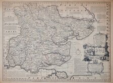
Emanuel Bowen 1720
Warburton Bland & Smyth 1726
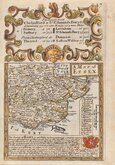
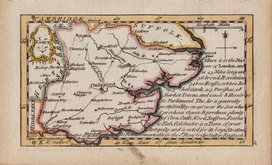
Thomas Read 1746 [1769]
Thomas Kitchin 1748 [1786]
Emanuel Bowen 1749
John Gibson 1759
Emanuel Bowen 1763


21x17 cm
FINAL ISSUE
ESSEX
This series of maps were first issued in The English Traveller, published in parts by the Fleet Street printer Thomas Read, from November 1743, with Essex appearing on 3 March 1743. Advertisements for the parts issues did not continue after September 1744, but if the weekly publication was maintained, the work was completed in November 1745. The speed of production would have required the employment of several engravers but none have been identified.
The complete three volume topographical work containing all the maps, The English Traveller…, was first issued in 1746.
On the death or retirement of Thomas Read, the maps passed into the hands of the Huguenot John Rocque (1704?-1762) who published them with a further 19 maps, probably also prepared by Read, with revisions to most maps, in The Small British Atlas… from 1753 to 1764. Their final appearance was in England Displayed…London: S.Bladon et.al...1769 and 1770.
This hand coloured example, with the plate number erased, was published in England Displayed...London, 1769.
Quick Links

Road Maps

Hertfordshire Maps
×