
Road Maps
Essex Maps
( Page 1 of 5 )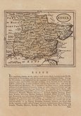
John Seller 1694 [1784]
Emanuel Bowen 1720
Warburton Bland & Smyth 1726
Thomas Read 1746 [1769]
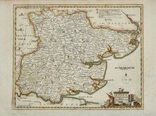
Thomas Kitchin 1748 [1786]
Emanuel Bowen 1749
John Gibson 1759
Emanuel Bowen 1763


24x19 cm
UNCOMMON. FINE HAND COLOUR.
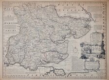
ESSEX.
Neele sc. Strand.
London, Pubd. as the Act directs, Decr. 1.st 1803, by J.Wilkes.
Engraved by Samuel Neele, this series of county maps were published in Encyclopaedia Londinensis; or, a universal dictionary of arts, sciences, and literature…Embellished by a most magnificent set of copper-plate engravings…Compiled, digested, and arranged, by John Wilkes… a twenty four volume work published betwwen 1801 and 1829. The maps were based on John Cary’s 1787 quarto series published in his New and Correct English Atlas. Variously dated 1801 to 1828, Bedfordshire, Berkshire, Buckinghamshire and Cambridge did not appear. The maps were not re-issued in this or any other publication.
Good example of the map of Essex dated 1803. In fine later hand colour. Uncommon.
Quick Links

Essex Prints

Hertfordshire Maps
×