
Road Maps
Essex Maps
( Page 1 of 5 )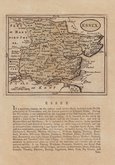
John Seller 1694 [1784]
Emanuel Bowen 1720
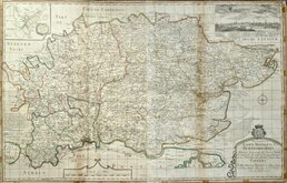
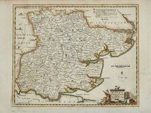
Warburton Bland & Smyth 1726
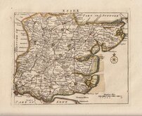
Thomas Read 1746 [1769]
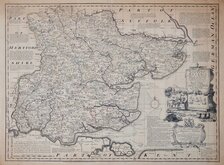
Thomas Kitchin 1748 [1786]
Emanuel Bowen 1749
John Gibson 1759
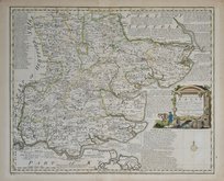
Emanuel Bowen 1763


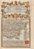
6x6 cm
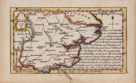
MINIATURE CIRCULAR MAP. RARE FIRST ISSUE.
ESSEX
Sold by J.Luffman 28 Little Bell Alley, Coleman St.t London.
Miniature circular copper engraved map by John Luffman published in a geographical text book entitled A New Pocket Atlas and Geography of England and Wales.
John Luffman (1751-1821), engraver, cartographer, printer, author, publisher and bookseller, was born in London, the son of Richard Luffman, gentleman, and his wife, Margaret Biggs. His first recorded engraving work was for road maps in An actual Survey of the great post roads between London and Edinburgh by Mostyn John Armstrong 1776 and Taylor and Skinners survey and maps of the roads of North Britain or Scotland, also 1776. He is best known for the production of these miniature circular maps although issues were small, Luffman publishing only two editions in 1803 with one further issue in 1806 by Lackington Allen & Co. The maps were unchanged in all editions with the exception of the placement of the plate number which was re-engraved close to the outer ring of the map border for Luffmans second issue of 1803.
This example of the map of Essex is from the rare first issue with the plate number '12' engraved 8mm above the map. There is also a faintly engraved '2' in the top right corner of the plate.
The plate edge is close to the top of the page and the typset text description below the map overlaps the plate edge into the map imprint.
Some toning to the paper but it remains a good example of a scarce map from the rare first edition in original hand colour.
Quick Links


Hertfordshire Maps
Essex Prints
×