
Essex Prints
Essex Maps
( Page 1 of 5 )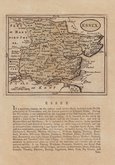
John Seller 1694 [1784]
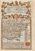
Emanuel Bowen 1720
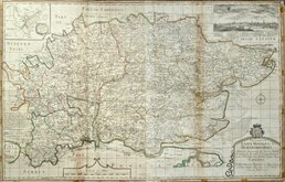
Warburton Bland & Smyth 1726
Thomas Read 1746 [1769]
Thomas Kitchin 1748 [1786]
Emanuel Bowen 1749
John Gibson 1759
Emanuel Bowen 1763


37x24 cm
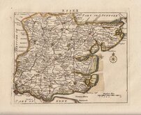
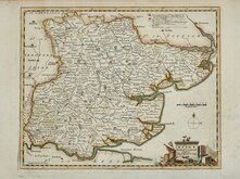
FIRST STEEL ENGRAVED MAP OF THE COUNTY
ESSEX.
Published by Pigot & Co. 24 Basing Lane London & Fountain St. Manchester
Engraved on Steel by Pigot & Son Manchester.
James Pigot produced the first National Directory for England and Wales and the maps that accompanied his directories represented a technological advance in printing, being the first set of county maps to be engraved on a steel plate rather than copper. Steel was less subject to wear, and the development of tools to enable the engraver to work on steel extended the useable life of the plate, and extended the print run. The reduction in wear to the plate also enabled the engraver to cut finer lines and to show more detail and during a period when maps were becoming more utilitarian with less decoration, it is likely that Pigot included a finely engraved and detailed cartouche of a notable local landmark to demonstrate the advantages of this new technology.
This series were first issued in parts from 1826, beginning with the home counties, followed by his directories and then in his Atlas, Pigot & Co,s British Atlas of the counties of England…
Includes a vignette of Saffron Walden Church.
Very good example in original hand colour without centrefold from the first edition published in Pigot & Co's British Atlas the First Part comprising London and the home counties issued without title page or text in 1826.
Quick Links

Road Maps

Hertfordshire Maps
×