
Hampshire Maps
Dorset Maps
( Page 1 of 3 )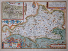
John Speed 1610 [1676]
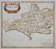
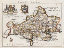
Robert Morden 1695
Robert Morden 1695
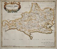
Owen & Bowen 1720
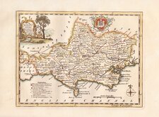
Robert Walker 1748
Thomas Kitchin 1750 [1786]
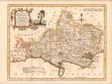
Thomas Kitchin 1764
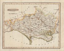
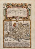
Benjamin Baker 1791


23x18 cm
UNCOMMON MAP FROM THE UNIVERSAL MAGAZINE OF KNOWLEDGE & PLEASURE.
DORSETSHIRE
Engraved by B.Baker Islington.
Copper engraving by Benjamin Baker (1766-1841) born in London, the third son of Edward Baker (1730-1797) mathematical instrument maker of Fetter Lane, he was apprenticed to a watchmaker, Thomas Beresford but turned over to Mapmaker, engraver and globemaker, William Palmer in 1782. He became principal engraver to The Ordnance survey in 1804.
The maps were prepared for publication in The Universal Magazine of Knowledge and Pleasure..., appearing in the issues between 1791-1797, published by W. Bent. This was the second series of county maps produced in the magazine, the first series by Emanuel Bowen and Thomas Kitchin was published between 1747-1766 by John Hinton. Baker's maps were based on the 'quarto' maps of John Cary published from 1787.
The maps also appeared unchanged in Maps of the Several Counties and Shires in England… published by Darton and Harvey in 1804. Laurie & Whittle acquired the plates and made a number of revisions including a compass rose behind the title and their imprint, publishing them in Laurie & Whittle's New and Improved English Atlas… 1807 & 1816.
Some offsetting from the printed text, folds as issued, and some small "rust" spots but it remains a good example of an uncommon map from the magazine issue.
Quick Links


Somerset Maps

Wiltshire Maps
×