
Yorkshire North Riding
Whole of Yorkshire
( Page 1 of 4 )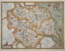
John Speed 1610 [1627]
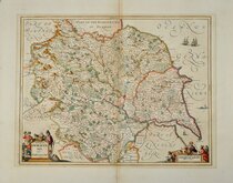
Jan Jansson 1646
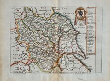
Richard Blome 1673
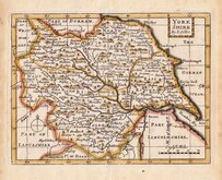
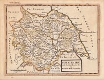
John Seller 1694
John Seller 1694 [c.1784]
Herman Moll 1724 [1753]
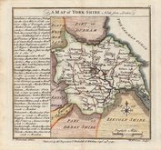
Badeslade, Thomas 1741
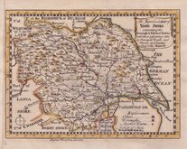
John Cowley 1743


15x19 cm
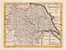
SCARCE JUVENILE PPUBLICATION.
YORKSHIRE
Lithographic transfer published in Reuben Ramble's Travels through the Counties of England by Darton & Clark (and Darton & Co.) between 1845 an 1850. The small map was first issued, printed from the copperplate, in a set of playing cards by Thomas Crabb c.1819, followed by Miller's New Miniature Atlas... Robert Miller, 1821, and Darton's New Miniature Atlas...William Darton, 1822 & 1825.
William Darton (1781-1854), the publisher above, was the son of William Darton (1755 -1819), engraver, bookseller, printer, publisher, map & print-seller, and children's author, born in Tottenham, the son of John Darton, innkeeper of The Coach and Six Horses. He was a pioneer in publications for children. Both William Darton jnr's sons, Thomas and William, took up the same business separately in 1804 and in partnership from 1806 until 1810. William later went into partnership with his son John Maw Darton (1810-1881) and on his retirement in 1837, John continued in partnership with Rev. Samuel Clark (1810-1875), as "Darton & Clark". It was this partnership that carried on the Darton family tradition of publishing children's works and produced the children's school atlas. Samuel Clark, under the pseudonym "Reuben Ramble", adding the topographical and historical views around the maps that had been in the possession of the Darton's for over 20 years, to "lure the youthful multitude into that most interesting and important of all studies - the geographical knowledge of their native land".
The survival rate of the Georgian school atlas was low and the maps are now scarce.
Toned with marking and scuffing. Closed tears left and right reaching map. Laid on matching paper. Original hand colour.
Quick Links


Yorkshire West Riding

Yorkshire East Riding
×