
Yorkshire North Riding
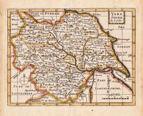
Whole of Yorkshire
( Page 1 of 4 )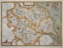
John Speed 1610 [1627]
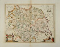
Jan Jansson 1646
Richard Blome 1673
John Seller 1694
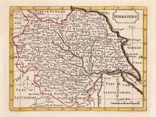
John Seller 1694 [c.1784]
Herman Moll 1724 [1753]
Badeslade, Thomas 1741
John Cowley 1743


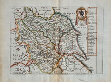
16x12 cm
FIRST ISSUE
YORK SHIRE
By I: Seller
John Seller (fl. 1660-1697), Hydrographer to Charles II, James II and Queen Anne, is renowned for his sea charts published in 1671 under the title The English Pilot. In 1679 he began work on an ambitious project to make a new survey of the counties of England and Wales and prepare a new county atlas Atlas Anglicanus. Despite financial support from the Treasury, the scheme floundered with only six counties completed. Possibly as a means of restoring his finances, Seller prepared a seres of small county maps, generally based on on John Speed's maps of 1610, and published them c.1694 under the titles Anglia Contracta and The History of England. There were only two issues of the maps before his death in 1697 but they were printed a few years later in Camden's Britannia abridg'd. [1701] and reprints of The History of England [1703]. The maps were not seen again for over 60 years when the plates were re-worked, incorporating some place name revisions and a plain title panel, and published in Francis Grose's Antiquities of England and Wales between 1784† and 1787* These later 'Grose editions usually included typeset text description of the county below the engraved map and continued verso.
†Some 1784 editions were given spurious dates on the title page of 1774 and 1777.
*1787 is the last given publication date for the work but maps have been found with dated watermarks up to 1815.
Very good hand coloured example of Yorkshire in the first state of the plate published from c.1694 to 1703.
ref. Whitaker, Maps of Yorkshire [140]
Quick Links


Yorkshire East Riding

Yorkshire West Riding
×