
Yorkshire West Riding
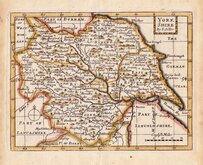
Whole of Yorkshire
( Page 1 of 4 )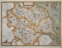
John Speed 1610 [1627]
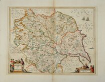
Jan Jansson 1646
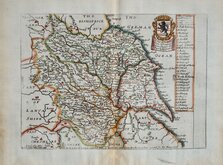
Richard Blome 1673
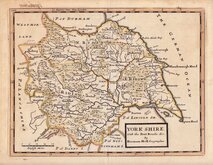
John Seller 1694
John Seller 1694 [c.1784]
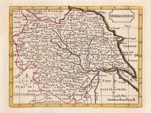
Herman Moll 1724 [1753]
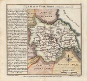
Badeslade, Thomas 1741
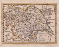
John Cowley 1743


15x14 cm
FIRST ISSUE
A MAP of YORK SHIRE North from London.
T. Badeslade delin. | W. H Toms Sculpt
Publish'd by the Proprietors T. Badeslade & W H Toms Sept r. 29 th 1741.
Drawn by Thomas Badeslade (fl.1717-1744) and engraved by William Henry Toms (fl.1723-1761) for publication in Chorographia Britannia...W H Toms, London 1742. The early imprints on the map indicate that the venture began as a partnership between Badeslade and Toms but by the time of publication, W.H.Toms is named as the sole proprietor on the title page of the work.
Little is known of Thomas Badeslade, a surveyor, draughtsman and engineer, his works include surveys of the rivers Ouse, Thames, and Humber, several surveys and maps of the Fens, and many views of country houses. He died at Finnant, Montgomeryshire in 1744.
William Henry Toms was born about 1701, son of Peter Toms, gentleman of the parish St. Margaret, Westminster. He was apprenticed to draughtsman, engraver and cartographer, John Harris (fl.1686-1730) on 30 April 1716. He became well established as engraver, print-seller, publisher and stationer working from various addresses in Holborn, Ludgate Hill, and Fleet Street from 1733 to 1755. He is last recorded in March 1761 imprisoned in the King's Bench for debt.
The pocket work Chorographia Britannia proved popular, running to several editions with a number of changes and additions to the plates within the first year and publication continuing until the end of the decade.
Very good hand coloured example in the first state of the map, dated 1741 and before the addition of several place names to the map and including the addition of Leeds in the side panel, published in Chorographia Britanniæ...[dated 1842 on the title page].
Ref. Whitaker Printed Maps of Yorkshire [183]
Quick Links


Yorkshire North Riding

Yorkshire East Riding
×