
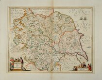
Yorkshire East Riding
Whole of Yorkshire
( Page 1 of 4 )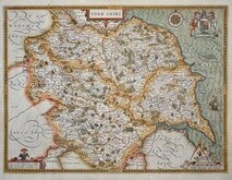
John Speed 1610 [1627]
Jan Jansson 1646
Richard Blome 1673
John Seller 1694
John Seller 1694 [c.1784]
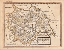
Herman Moll 1724 [1753]
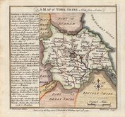
Badeslade, Thomas 1741
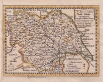
John Cowley 1743


50x38 cm
SET OF FOUR MAPS
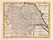
YORKSHIRE, PART OF THE NORTH RIDING &c.
YORKSHIRE, NORTH RIDING &c.
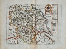
YORKSHIRE, WEST RIDING.
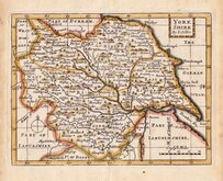
YORKSHIRE, PARTS OF THE EAST & WEST RIDING.
All with the imprint:
Drawn & Engraved by J.Archer, Pentonville, London.
First published in Curiosities of Great Britain, England and Wales Delineated…by Thomas Dugdale by L.Tallis in 1842. The work was re-issued a number of times until 1860. The maps also appeared in The Universal English Dictionary…by the Rev. James Barclay and finally in Tallis's topographical dictionary of England & Wales in 1860.
Joshua Archer (c.1792-1863), Engraver, cartographer and copperplate printer, was born in Barnstaple in Devon. His first recorded work as an engraver was a map of Scotland for Robert Wilkinson in 1814. He was declared bankrupt in 1835, imprisoned for debt in 1845, but on the 1861 census, he is recorded as a map and chart engraver aged 69, living in Islington with his wife Jane, a son, John, also a map and chart engraver, Albert Archer, map and chart draughtsman, Albert’s wife Elizabeth and their three children.
A good clean set in original outline hand colour from the 1848 edition of Dugdales Curiosities.
Each plate measures approx 24x18cm.
Ref. Whitaker Printed Maps of Yorkshire [493]
Quick Links


Yorkshire West Riding

Yorkshire North Riding
×