
Yorkshire North Riding
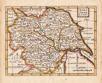
Whole of Yorkshire
( Page 1 of 4 )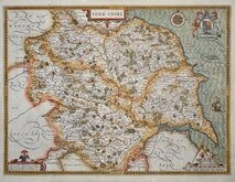
John Speed 1610 [1627]
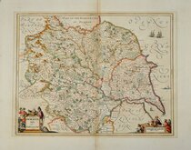
Jan Jansson 1646
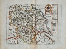
Richard Blome 1673
John Seller 1694
John Seller 1694 [c.1784]
Herman Moll 1724 [1753]
Badeslade, Thomas 1741
John Cowley 1743


84x60 cm
FOUR SHEETS FROM THE FIRST ISSUES WITH MAGAZINE BLIND STAMPS
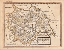
YORKSHIRE (NORTH WEST SHEET)
E.Weller. Lithogr.
THE DISPATCH ATLAS
[Partial corner blind stamp]: SUPPLEMENT TO THE WEEKLY DISPATCH OF SUNDAY JUNE 22ND.1862
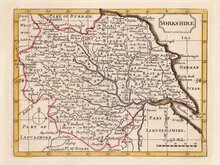
YORKSHIRE (NORTH EAST SHEET)
THE DISPATCH ATLAS
YORKSHIRE
BY EDWD. WELLER, F.R.G.S.
E. Weller Lithogr.
[Partial corner blind stamp]: SUPPLEMENT TO THE WEEKLY DISPATCH OF SUNDAY JUNE 1ST.1862
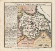
YORKSHIRE (SOUTH WEST SHEET)
Weekly Dispatch Atlas 139 Fleet Street.
E. Weller Lithogr.
THE DISPATCH ATLAS
[Partial corner blind stamp]: SUPPLEMENT TO THE WEEKLY DISPATCH OF SUNDAY MAY 25TH.1862
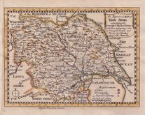
YORKSHIRE (SOUTH EAST SHEET)
E. Weller Lithogr.
THE DISPATCH ATLAS
Engraved by Edwd. Weller 34, Red Lion Square.
[No blind stamp]
This series of county maps, engraved by Edward Weller, F.R.G.S. (1819-1884), one of the pioneers of lithograph printed maps, were first published in Sunday supplements to the Weekly Dispatch newspaper between 1856 and 1862. Printed by lithographic transfer from an engraved plate, the plates not used for direct intaglio printing. When the series was complete the maps were published, in The Dispatch Atlas in 1863. Publishers Cassell Petter and Galpin acquired the plates and issued them in Cassell's Illustrated family paper and Cassell's British Atlas in 1867, By 1869, the firm of G. W. Bacon had acquired the plates and issued them in a number of titles for over forty years.
These four plates, each measuring approx 30x42cm., are from the first publication issued in Sunday supplements of the Dispatch newspaper in May and June 1862; on May 18th (South East) , May 25th, (South West), June 1st (North East and title sheet), and June 2nd (north West). The four plates when pasted together form a map measuring approx 84x60cm.
A few short tears to paper edges not affecting the printed area and some light folds and creasing but they are a good set from the first issues in original hand colour.
Ref. Harold Whitaker Printed Maps of Yorkshire [542]
Quick Links


Yorkshire East Riding

Yorkshire West Riding
×