
Waterways & Railways
Town Plans
( Page 1 of 13 )
Cambridge, King's St. John's & Trinity
Ely 1729
Durham 1804
Colchester 1805
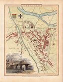
Carlisle 1805
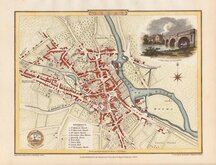
Derby 1806

Norwich 1807
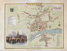
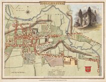
Bedford 1807


24x19 cm
BEDFORD | Drawn and Engraved under the direction of E W Brayley. | Engraved by J. Roper from a Drawing by G. Cole | to accompany the Beauties of England and Wales | London Published for the Proprietors by Vernor, Hood & Sharpe, Poultry, Apr. 1.1807
Engraved by J. Roper and drawn by George Cole with vignette engraved by J. Greig from a drawing by Edward Dayes. This series of plans were intended to accompany The Beauties of England and Wales but were not actually published with this work. First issued in parts as a separate series between 1804 and 1810 they first appeared in atlas form with county maps, also mostly drawn by Cole and engraved by Roper, in The British Atlas published by Vernor Hood & Sharpe (& nine other publishers) in 1810. The county maps were re-issued in several publications including Dugdale's Curiosities of Great Britain until 1843 with their final appearance by lithographic transfer in Collins' railway and pedestrian atlas… published by Darton and Co. in 1858. The town plans in comparison had a limited publication period and were issued only with The British Atlas.
Fine hand coloured example of Bedford. Vignette of Bedford Bridge with S.t Pauls Church and part of the Town drawn by W.H.Pine and engraved by G. Cooke. Inset miniature plan of the House of Industry.
Quick Links

London Maps

Road Maps
×