
Wales Maps
Shropshire Maps
( Page 1 of 3 )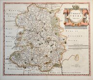
Robert Morden 1695 [1753]
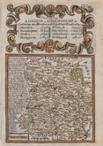
Emanuel Bowen 1720
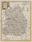
Thomas Kitchin 1763
Thomas Kitchin 1763
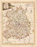
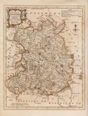
Joseph Ellis 1765 [1773]
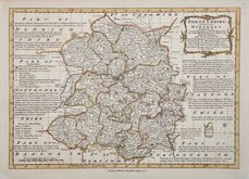
Emanuel Bowen 1767 [1770]
John Haywood 1788
John Cary 1789 [1805]


32x23 cm
UNCOMMON MAP FROM ATLAS ANGLICANUS.
SHROPSHIRE Divided into HUNDREDS, Exhibiting the County, Burough & Market Towns &c. with concise Historical Extracts, relative to its Natural Produce; with an Account of the Trade & Manufactures of the Principal Towns. Describing also the Church Livings; with Improvements not Inserted in any other Set of Half Sheet County Maps Extant. By Eman: Bowen, Geogr. to His late Majesty, & Thos. Bowen.
This series of maps were based on the large maps produced for the Large English Atlas by Thomas Kitchin and Emanuel Bowen from about 1749. Various publishers were involved in the troubled and expensive production of the large maps and the subsequent productions of smaller maps in the Royal English Atlas and Atlas Anglicanus were attempts at recouping some of the expenses incurred for the original surveys and publication.
Neither of the smaller derivatives achieved the sales success made by the Large English Atlas and surviving examples are uncommon.
There were three issues of the map with the rococo title cartouche in 1767, 1770 and 1777. The plates were then acquired by Carington Bowles who erased the title, replacing it with a simple oval title panel and published them in his New Medium Atlas in 1785. Individual county maps are recorded as being being offered for sale by Bowles and Carver untiil at least 1798.
It is noted in the title that his son, Thomas, worked with him on this, his final work, the publication of which coincided with his death in 1767.
Fine example in outline hand colour of the map of Shropshire from the 1770 or 1777 issue of Atlas Anglicanus.
Quick Links


Herefordshire Maps

Staffordshire Maps
×