
Gloucestershire Maps
Herefordshire Maps
( Page 1 of 3 )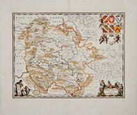
Jan Jansson 1646 [c.1681]
John Seller 1694 [1784]
Robert Morden 1695 [1753]
Emanuel Bowen 1720
Joseph Ellis 1765 [1773]
John Haywood 1787
John Cary 1789 [1791]
John Cary 1789 [1805]


50x38 cm
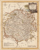
DECORATIVE DUTCH MAP
HEREFORDIAE COMITATUS Vernacule HEREFORDSHIRE
Amstelodami Apud P. Schenk et G. et G. Valk.
Copper engraving by Dutch engraver and publisher, Jan Jansson (1588-1664) issued in his Ioannis Ianssonii Novus Atlas from 1646. Following the publication of a volume of county maps of England and Wales by his rival mapmaker and publisher Jan Blaeu in 1645, Jansson produced his version just one year later matching the superb engraving standard of his rival Blaeu. There were a number of editions of Jansson's work in various languages between 1646 and 1667. Until 1658 the atlas was issued in four or five volumes with the British maps in the fourth volume, later editions expanded to eleven volumes. In 1681 Pieter Schenk and Gerard Valck had acquired the plates and began re-issues with their imprint as loose sheets sold separately and in 1714, 1715 and 1724 in Atlas Anglois, ou description general de l'Angleterre...
This example of the map of Herefordshire has the imprint of Schenk & Valk and was issued from 1681 to 1724.
Very good conition. Fine hand colour.
Quick Links


Wales Maps

Worcestershire Maps
×