
Wales Maps
Shropshire Maps
( Page 1 of 3 )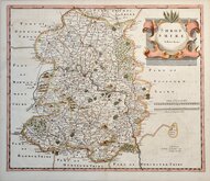
Robert Morden 1695 [1753]
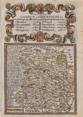
Emanuel Bowen 1720
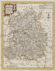
Thomas Kitchin 1763
Thomas Kitchin 1763
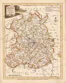
Joseph Ellis 1765 [1773]
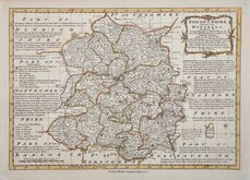
Emanuel Bowen 1767 [1770]
John Haywood 1788
John Cary 1789 [1805]


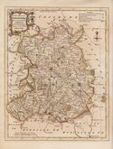
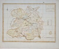
7x12 cm
COLOURFUL MINIATURE MAP
SHROPSHIRE.
Pub. by M.A.Leigh 421 Strand. | Sidy.Hall sculpt.
Miniature map engraved by Sidney Hall and first published by Samuel Leigh in Leigh's New Pocket Atlas of England and Wales in 1820. The demand for pocket atlases for the traveller was high during the first half of the 19th century and this little atlas, Samuel Leigh's only cartographic work, was very popular, running to three editions with a further eight editions after his death by his widow Mary Ann and then his son until 1839. The plates were then acquired by George Biggs who published two more editions until 1843.
Sidney Hall (1788?-1831), began work as an engraver about 1809 and was in partnership with Michael Thomson (fl.1809-1815) as "Thomson & Hall" in 1814. Hall was a pioneer of engraving on steel and is almost certainly the first engraver to use steel plates for map engraving, producing steel engraved maps from 1821. He married Selina Price in 1821 but died early in 1831 aged forty-two. Selina carried on his engraving business signing her maps "S. Hall" which has caused some confusion in map bibliographies.
Good hand coloured example from the 1834 edition published BY Mary Ann Leigh following the Reform Bill and showing the new internal county divisions.
SPECIAL OFFER MOUNT OPTION AVAILABLE ON THIS ITEM AT CHECKOUT FOR UK DELIVERY.
Quick Links


Herefordshire Maps

Staffordshire Maps
×