
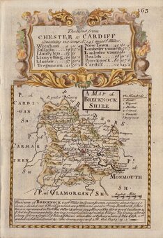
Brecknockshire
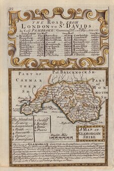
Monmouthshire
( Page 1 of 3 )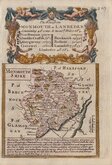
Emanuel Bowen 1720
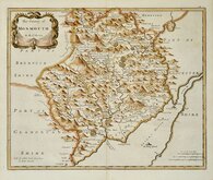
Robert Morden 1753
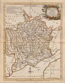
Joseph Ellis 1773
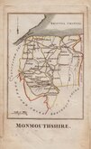
Robert Butters 1803
John Cary 1805
Cole & Roper 1807
John Cary 1809
Cole & Roper 1810


12x18 cm
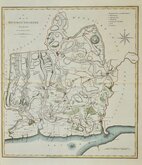
MONMOUTH SHIRE
Copper engraving by Emanuel Bowen published in the pocket road book Britannia Depicta by Thomas Bowles from 1720. This was the first truly pocket sized road book for the traveller based on the surveys of John Ogilby published in large folio format 45 years earlier in 1675. It was the last and most successful of four separate schemes to produce such a work within the space of two years and extended to over fifteen editions until 1764. The other road books were by Herman Moll which was not completed, Thomas Gardner published in a single edition in 1719 and John Senex of 1720 which ran to about six editions with a number of derivatives. The works by Gardner and Senex were simple reductions of John Ogilby's plates but Britannia Depicta included a wealth of historical, topographical and informative notes compiled by John Owen together with the arms of major towns and important people and a set of small county maps. The county maps were all based on Robert Morden's small series published in 1701. For the strip maps, the Ogilby folio maps were copied onto two plates to maintain a reasonable scale while keeping the work pocket size.The space above the shorter central pair of strips which accommodated Ogilby's title were now on the left or right of a page and usually filled with a coat of arms. The titles to the routes were included on a separate page, often above a county map relevant to the route. The plates were printed on both sides of the paper, reducing the weight of the volume. Printing on both sides of the page was a considerable undertaking, as the sticky ink required for the process of copperplate printing needed an extensive drying-off period before being handled again for a second printing. The notes by John Owen were engraved by Emanuel Bowen on the copperplate surrounding the road maps and also on separate plates. The maps have become commonly known as "Owen & Bowen" maps.
The map is set below a decorative cartouche containing the title for the road from Monmouth to Llanbeder and has the first part of that road verso.
Small left margin. A very good early example in neat later hand colour.
Quick Links
Glamorganshire

Herefordshire Maps
×