
Northamptonshire Maps
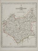
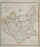
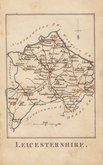
Leicestershire Maps
( Page 1 of 3 )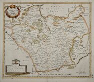
Robert Morden 1695 [1753]
Emanuel Bowen 1720
Joseph Ellis 1765 [1773]
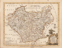
John Haywood 1787 [1791]
John Cary 1787 [1793]
John Cary 1789 [1805]
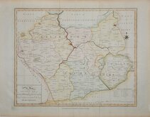
Robert Butters 1803
John Cary 1808 [1809]


24x19 cm
WOOD ENGRAVING
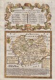
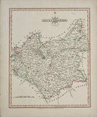
No. LXIII.] GUIDE TO KNOWLEDGE. PRICE ONE PENNY.
LEICESTER SHIRE
London W.Edwards 12 Ave Maria Lane.
J.Archer sc 100 Drummond Str. Euston Sq.
Woodblock engraved map by Joshua Archer published in weekly parts in The Guide to Knowledge…edited by W Pinnock...W. Edwards, London. 1833-34.
The printing method, whereby an engraved woodblock was inked over the surface with a roller without working the ink into the engraved cuts, resulting in a white line on a black ground, was not suited to topographical maps and this is the only series of maps to use the method.
The guide was re-issued in 1838 and some of the maps appeared, with a decorative border using coloured inks, in A Descriptive county atlas of England and Wales by Groombridge, Shepherd & Sutton in 1844. The final use of the maps, printed more conventionally by lithographic transfer from the Groombridge amended woodblocks, was in Johnson's Atlas of England in 1847 Following the rapid development of the railway network the maps were noticeably out of date by this time and were not popular and surviving examples from this publication are rare. One further, extremely rare issue of the Johnson atlas, printed from remaindered sheets, was published with a manuscript amended date on the title page of 1863, surviving today in only a handful of examples.
The author of the Guide to Knowledge, William Pinnock (1782-1843), born in Alton Hampshire, was a schoolmaster. In 1817 he moved to London and, in partnership with Samuel Maunder, began the publication of cheap educational works.
Joshua Archer (c.1792-1863), engraver, cartographer and copperplate printer, was born in Barnstaple in Devon. His first recorded work as an engraver was a map of Scotland for Robert Wilkinson in 1814. He was declared bankrupt in 1835, imprisoned for debt in 1845, but is recorded on the 1861 census as a map and chart engraver aged 69, living in Islington with his wife Jane, a son John, also a map and chart engraver, Albert Archer, a map and chart draughtsman, his wife Elizabeth and three children.
A good example of the woodblock printed map.
Quick Links


Staffordshire Maps

Warwickshire Maps
×