
Warwickshire Maps
Leicestershire Maps
( Page 1 of 3 )
Robert Morden 1695 [1753]
Emanuel Bowen 1720
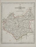
Joseph Ellis 1765 [1773]
John Haywood 1787 [1791]
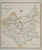
John Cary 1787 [1793]
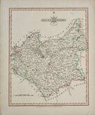
John Cary 1789 [1805]
Robert Butters 1803
John Cary 1808 [1809]


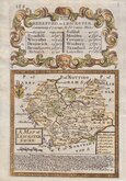
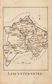
12x18 cm
FROM "OWEN & BOWEN" ROAD BOOK BRITANNIA DEPICTA.
A MAP of LEICESTER SHIRE.
Map set below a decorative cartouche containing the title and details of the road from Hereford to Leicester..
Road map of the second part of the route from Gloucester to Montgomery verso.
Engraved text descriptions below the county map and alongside and below the road map.
Engraved by Emanuel Bowen (1693?-1767) and published in the pocket road book Britannia Depicta by Thomas Bowles from 1720 to 1764. The county maps were based on Robert Morden's small series published in The New Description and State of England... from 1701. Text descriptions compiled by John Owen.
Small repaired nick to top edge above the title cartouche.
For full description of the road, go to category: Maps > British Isles > RoadMaps > Owen & Bowen. For more information on Britannia Depicta, see the category heading under Road Maps > Owen & Bowen.
Quick Links


Northamptonshire Maps

Staffordshire Maps
×