
Lancashire Maps
Isle of Man
( Page 1 of 2 )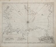
Greenville Collins Irish Sea 1688 [c.1693]
Thomas Read 1743 [1753]
Thomas Kitchin 1763
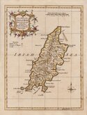
Joseph Ellis 1765 [1773]
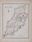
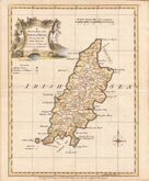
Roger Creighton 1831
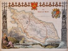
Thomas Moule 1843
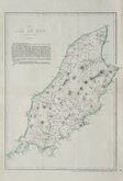
Edward Weller 1863 [1867]
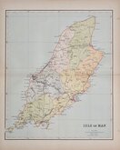
Francis Weller 1891


16x20 cm
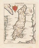
ROCQUE EDITION
The Isle of MAN.
Based on John Speed's outline (with the coasts of England Scotland Ireland and Wales drawn at a different scale) but including information from the map in Daniel King's Short Treatise on the Isle of Man London 1656, Thomas Read, the printer, published the series of maps in weekly issues from 26 November 1743 to 1 September 1744. The rate of production would have necessitated the employment of several engravers but none have been identified. The Isle of Man appeared in the issue for the 25th Feb. 1743.
The three volume topographical work containing all the maps, The English Traveller…, was first issued in 1746.
On the death or retirement of Thomas Read, his maps passed into the hands of Huguenot John Rocque who published them with a further 19 maps, probably also prepared by Read, and with revisions to most maps, in The Small British Atlas… from 1753 to 1764 and in England Displayed… in 1769 and 1770.
This example has no plate number but traces of plate number 53 remain which identifies it as the third state of the plate published in The Small British atlas by John Rocque in 1753.
Fine hand coloured example.
SPECIAL OFFER MOUNT OPTION AVAILABLE ON THIS ITEM AT CHECKOUT FOR UK CUSTOMERS.
Quick Links


Whole of Britain & British Isles

Folding Maps
×