
Folding Maps
Isle of Man
( Page 1 of 2 )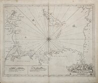
Greenville Collins Irish Sea 1688 [c.1693]
Thomas Read 1743 [1753]
Thomas Kitchin 1763
Joseph Ellis 1765 [1773]
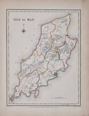
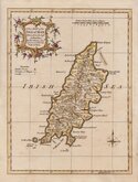
Roger Creighton 1831
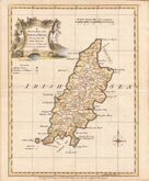
Thomas Moule 1843
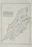
Edward Weller 1863 [1867]
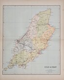
Francis Weller 1891


20x26 cm
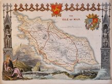
"DUKE OF YORK" SERIES
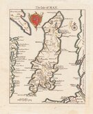
A New MAP of the ISLE of MAN Drawn from the best Authorities: By Tho,,s Kitchin Geog,,r Engraver to H.R.H. the Duke of York.
Copper engraving by Thomas Kitchin published in England Illustrated, or, a compendium of natural history, geography, topography…Robert and James Dodsley, 1764 [1763].
Thomas Kitchin (1719-1784), engraver, cartographer and publisher, born in London 4th August 1719, the son of Thomas Kitchin, hat-dyer, and his wife Mary Birr. Apprenticed to Emanuel Bowen (1693-1767) 6th December 1732 to 6th August 1746. He married his master’s daughter, Sarah Bowen, during his apprenticeship, 25th December 1739. Their son, Thomas Bowen Kitchin was born about 1740. An active Baptist, he was deacon of the Barbican Baptist Chapel in 1768 and married Jane Burroughs (1720?-1789), daughter of celebrated baptist preacher Joseph Burroughs (1685-1761). Engraver to the Duke of York from about 1758. Traded as Thomas Kitchin & Son from 1769 and was Hydrographer to the King from 1773. He probably retired sometime around 1776, his premises at The Star, Holborn Hill, which may have been run by his son since their partnership, was taken over by William Hawkes, an apprentice of his son in 1776/1777. He moved to Fishpool Street, St Albans in 1768 and died 23rd June 1784. He was buried in a private vault at St Albans Abbey, his memorial stone on the floor of the Abbey has not survived.
Robert Dodsley, the publisher of these maps, often known as The Duke of York series after the dedication in the title of each map, took his younger brother, James into partnership by 1755 and together published England Illustrated in December 1763, post-dated 1764.
The work was re-issued in monthly parts early in 1764. Robert Dodsley died on 23rd September but the parts issues continued until completion on 1st January 1765. The maps appeared once more in 1765 in an atlas publication without text under the title Kitchen's (sic) English Atlas; Or, A Compleat Set of Maps Of All The Counties of England and Wales…By Thomas Kitchen, Geographer to his Royal Highness the Duke of York. London: Printed for J. Dodsley, in Pall-Mall.
A fine example in neat later hand colour.
Quick Links


Lancashire Maps

Whole of Britain & British Isles
×